List of highest mountain peaks of California
The following sortable table lists the 16 mountain peaks of the U.S. State of California with at least 4000 meters (13,123.4 feet) of topographic elevation and at least 500 meters (1640.4 feet) of topographic prominence.
Topographic elevation is the vertical distance above the reference geoid, a precise mathematical model of the Earth's sea level as an equipotential gravitational surface. Topographic prominence is the elevation difference between the summit and the highest or key col to a higher summit. Topographic isolation is the minimum great circle distance to a point of higher elevation.
This article defines a significant summit as a summit with at least 100 meters (328.1 feet) of topographic prominence, and a major summit as a summit with at least 500 meters (1640.4 feet) of topographic prominence. An ultra-prominent summit is a summit with at least 1500 meters (4921.3 feet) of topographic prominence.
4000 meter peaks
Note: Compare this list with the List of California fourteeners which includes peaks with at least 4267.2 meters (14,000 feet) of elevation and at least 91.44 meters (300 feet) of topographic prominence. The five highest peaks are the same on both lists, but this list of 4000 meter peaks excludes low prominence summits like Mount Sill, and includes high prominence, although slightly lower, peaks like Mount Humphreys.
Gallery
-

1. Mount Whitney is the highest summit of the Sierra Nevada, the State of California, and the contiguous United States.
-

2. Mount Williamson is the second highest mountain peak of California.
-

3. White Mountain Peak is the highest summit of the White Mountains.
-

4. North Palisade is the highest summit of the Palisades of the Sierra Nevada.
-

5. The stratovolcano Mount Shasta is the second most topographically prominent California mountain peak.
-

6. Mount Humphreys in the Sierra Nevada.
-
8. Mount Darwin is the highest summit of the Evolution Peaks of the Sierra Nevada.
-

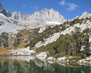
12. Mount Tom in the Sierra Nevada.
See also
- The 123 4000 metre peaks of North America
- The 17 4000 metre peaks of Canada
- The 104 4000 meter peaks of the United States
- The 23 4000 meter peaks of Alaska
- The 16 4000 meter peaks of California
- The 55 4000 meter peaks of Colorado
- The 9 4000 metre peaks of México
- The 2 4000 metre peaks of Central America
- Lists of mountains
- Mountain peaks of North America
- Physical geography
- State of California
- Geography of California
- Category:Mountains of California
- Geography of California
References
- ↑ The summit of Mount Whitney is the highest point of the Sierra Nevada, the State of California, and the contiguous United States.
- ↑ "Mount Whitney". Datasheet for NGS Station GT1811. United States National Geodetic Survey. Retrieved March 30, 2012.
- ↑ The elevation of Mount Whitney includes an adjustment of +1.869 m (+6.13 ft) from NGVD 29 to NAVD 88.
- ↑ "Mount Whitney". Summits of the World. peakbagger.com. Retrieved March 30, 2012.
- ↑ The elevation of Mount Williamson includes an adjustment of +1.807 m (+5.93 ft) from NGVD 29 to NAVD 88.
- ↑ "Mount Williamson". Summits of the World. peakbagger.com. Retrieved March 30, 2012.
- ↑ The summit of White Mountain Peak is the highest point of the White Mountains.
- ↑ "White Mountain Peak". Datasheet for NGS Station HR2559. United States National Geodetic Survey. Retrieved March 30, 2012.
- ↑ The elevation of White Mountain Peak includes an adjustment of +1.910 m (+6.27 ft) from NGVD 29 to NAVD 88.
- ↑ "White Mountain Peak". Summits of the World. peakbagger.com. Retrieved March 30, 2012.
- ↑ The summit of North Palisade is the highest point of the Palisades and the central Sierra Nevada.
- ↑ "North Palisade". Datasheet for NGS Station HR2629. United States National Geodetic Survey. Retrieved March 30, 2012.
- ↑ The elevation of North Palisade includes an adjustment of +1.867 m (+6.13 ft) from NGVD 29 to NAVD 88.
- ↑ "North Palisade". Summits of the World. peakbagger.com. Retrieved March 30, 2012.
- ↑ The summit of Mount Shasta is the highest point of the southern Cascade Range.
- ↑ "Mount Shasta". Datasheet for NGS Station MX1016. United States National Geodetic Survey. Retrieved March 30, 2012.
- ↑ The elevation of Mount Shasta includes an adjustment of +1.791 m (+5.88 ft) from NGVD 29 to NAVD 88.
- ↑ "Mount Shasta". Summits of the World. peakbagger.com. Retrieved March 30, 2012.
- ↑ "Mount Humphreys". Datasheet for NGS Station HR2626. United States National Geodetic Survey. Retrieved March 30, 2012.
- ↑ The elevation of Mount Humphreys includes an adjustment of +1.842 m (+6.04 ft) from NGVD 29 to NAVD 88.
- ↑ "Mount Humphreys". Summits of the World. peakbagger.com. Retrieved March 30, 2012.
- ↑ "Mount Keith". Datasheet for NGS Station GT1807. United States National Geodetic Survey. Retrieved March 30, 2012.
- ↑ The elevation of Mount Keith includes an adjustment of +1.795 m (+5.89 ft) from NGVD 29 to NAVD 88.
- ↑ "Mount Keith". Summits of the World. peakbagger.com. Retrieved March 30, 2012.
- ↑ "Mount Darwin". Datasheet for NGS Station HR2631. United States National Geodetic Survey. Retrieved March 30, 2012.
- ↑ The elevation of Mount Darwin includes an adjustment of +1.886 m (+6.19 ft) from NGVD 29 to NAVD 88.
- ↑ "Mount Darwin". Summits of the World. peakbagger.com. Retrieved March 30, 2012.
- ↑ The summit of Mount Kaweah is the highest point of the Great Western Divide.
- ↑ The elevation of Mount Kaweah includes an adjustment of +1.652 m (+5.42 ft) from NGVD 29 to NAVD 88.
- ↑ "Mount Kaweah". Summits of the World. peakbagger.com. Retrieved March 30, 2012.
- ↑ "Mount Morgan". Datasheet for NGS Station HR2627. United States National Geodetic Survey. Retrieved March 30, 2012.
- ↑ The elevation of Mount Morgan includes an adjustment of +1.853 m (+6.08 ft) from NGVD 29 to NAVD 88.
- ↑ "Mount Morgan". Summits of the World. peakbagger.com. Retrieved March 30, 2012.
- ↑ The elevation of Mount Gabb includes an adjustment of +1.958 m (+6.42 ft) from NGVD 29 to NAVD 88.
- ↑ "Mount Gabb". Summits of the World. peakbagger.com. Retrieved March 30, 2012.
- ↑ "Mount Tom". Datasheet for NGS Station HR2770. United States National Geodetic Survey. Retrieved March 30, 2012.
- ↑ The elevation of Mount Tom includes an adjustment of +1.379 m (+4.52 ft) from NGVD 29 to NAVD 88.
- ↑ "Mount Tom". Summits of the World. peakbagger.com. Retrieved March 30, 2012.
- ↑ The elevation of Mount Dubois includes an adjustment of +1.879 m (+6.16 ft) from NGVD 29 to NAVD 88.
- ↑ "Mount Dubois". Summits of the World. peakbagger.com. Retrieved March 30, 2012.
- ↑ The elevation of Mount Pinchot includes an adjustment of +1.810 m (+5.94 ft) from NGVD 29 to NAVD 88.
- ↑ "Mount Pinchot". Summits of the World. peakbagger.com. Retrieved March 30, 2012.
- ↑ "Red Slate Mountain". Datasheet for NGS Station HR2690. United States National Geodetic Survey. Retrieved March 30, 2012.
- ↑ The elevation of Red Slate Mountain includes an adjustment of +1.893 m (+6.21 ft) from NGVD 29 to NAVD 88.
- ↑ "Red Slate Mountain". Summits of the World. peakbagger.com. Retrieved March 30, 2012.
- ↑ The elevation of Mount Ritter includes an adjustment of +1.786 m (+5.86 ft) from NGVD 29 to NAVD 88.
- ↑ "Mount Ritter". Summits of the World. peakbagger.com. Retrieved March 30, 2012.
External links
| Wikimedia Commons has media related to Mountains of California. |
- National Geodetic Survey (NGS)
- United States Geological Survey (USGS)
- peakbagger
- peaklist.org
- summitpost.org
- World Mountain Encyclopedia @ peakware.com
| ||||||||||