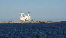
Hestskjær Lighthouse
 | |
 | |
| Location | Møre og Romsdal, Norway |
|---|---|
| Coordinates | 63°05′04″N 07°29′32″E / 63.08444°N 7.49222°ECoordinates: 63°05′04″N 07°29′32″E / 63.08444°N 7.49222°E |
| Year first constructed | 1879 |
| Automated | 1986 |
| Height | 21 metres (69 ft) |
| Focal height | 24 metres (79 ft) |
| Intensity | 28,200 candela |
| Range | 15 nmi (28 km; 17 mi) |
| Characteristic | Oc (2) WRG 8s |
| Racon | K |
| Admiralty number | L1022 |
| NGA number | 6644 |
| ARLHS number | NOR-401 |
| Norway number | 375500 |
Hestskjær Lighthouse (Norwegian: Hestskjær fyr) is a coastal lighthouse located in Averøy Municipality in Møre og Romsdal county, Norway. It is located on a small island about 2 kilometres (1.2 mi) north of the village of Langøy. The lighthouse was established in 1879 and automated in 1986.[1][2]
The 21-metre (69 ft) tall lighthouse emits a white, red, or green light (depending on direction) occulting twice every 8 seconds. The tower is a round, cylindrical tower that is white with a red top. The 28,200 candela light can be seen for up to 15 nautical miles (28 km; 17 mi).[3][4]
World War II
On 13 February 1944, the two ships SS Irma and SS Henry were sunk near Hestskjær.
References
- ↑ Henriksen, Petter (ed.). "Hestskjær fyr". Store norske leksikon (in Norwegian). Oslo: Kunnskapsforlaget. Retrieved 17 December 2011.
- ↑ "Hestskjær fyrstasjon" (in Norwegian). Norsk Fyrhistorisk Forening. Retrieved 17 December 2011.
- ↑ Rowlett, Russ (19 July 2011). "Lighthouses of Norway: Kristiansund Area". University of North Carolina at Chapel Hill. Retrieved 2013-05-05.
- ↑ Kystverket (2012). Norske Fyrliste 2012 (PDF) (in Norwegian). ISBN 9788245013542.
This article is issued from Wikipedia - version of the Wednesday, April 15, 2015. The text is available under the Creative Commons Attribution/Share Alike but additional terms may apply for the media files.