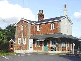
Ham Street railway station
| Ham Street | |
|---|---|
 | |
| Location | |
| Place | Hamstreet |
| Local authority | Ashford |
| Grid reference | TR000337 |
| Operations | |
| Station code | HMT |
| Managed by | Southern |
| Number of platforms | 2 |
| DfT category | E |
|
Live arrivals/departures, station information and onward connections from National Rail Enquiries | |
| Annual rail passenger usage* | |
| 2004/05 | 58,394 |
| 2005/06 |
|
| 2006/07 |
|
| 2007/08 |
|
| 2008/09 |
|
| 2009/10 |
|
| 2010/11 |
|
| 2011/12 |
|
| 2012/13 |
|
| 2013/14 |
|
| History | |
| Key dates | Opened 13 February 1851 |
| National Rail – UK railway stations | |
| * Annual estimated passenger usage based on sales of tickets in stated financial year(s) which end or originate at Ham Street from Office of Rail and Road statistics. Methodology may vary year on year. | |
| UK Railways portal | |
Ham Street railway station serves Hamstreet in Kent, England. It is on a dual-track section of the unelectrified Marshlink Line, and train services are provided by Southern. Like Pluckley station nearby, it features staggered platforms, the southbound platform being south of the Ashford-bound one.
Train services are operated by Class 171 Turbostar diesel trains.
The booking office - open on Mondays to Saturdays mornings - is located in the main station building on the Ashford-bound platform. The two PERTIS passenger-operated self-service ticket machines - one on each platform - have now been removed and replaced with Ticket Vending machines on each platform,[1] which allows a ticket to be purchased from any origin, as opposed to just from Ham Street. The PERTIS passenger-operated self-service machines were installed in connection with a Penalty Fares Scheme in 2008.
A temporary footbridge has been provided in 2014, replacing the previous flat crossing of the railway
Services
The typical service is:
- 1 train per hour (tph) to Ashford International. Most passengers who wish to travel to London change here, and since Winter 2009 customers have been able to change to High Speed services to St. Pancras International with a journey time of 37 minutes from Ashford International.[2]
- 1 train per hour to Brighton, calling at Appledore (Kent), Rye, Hastings, St Leonards Warrior Square, Bexhill, Eastbourne, Hampden Park (Sundays only), Polegate (every day), Berwick (Sundays only), Glynde (Sundays only) and Lewes (every day)
- At peak times an additional shuttle service runs hourly between Ashford International and Rye giving two trains an hour in each direction.
| Preceding station | |
Following station | ||
|---|---|---|---|---|
| Appledore (Kent) | Southern Marshlink Line |
Ashford International | ||
References
- ↑ "New ticket buying options". Southern News East Coastway. Spring 2011. p. 3.
- ↑ http://www.southeasternrailway.co.uk/highspeed/
External links
- Train times and station information for Ham Street railway station from National Rail
Coordinates: 51°04′05″N 0°51′18″E / 51.068°N 0.855°E
| ||||||||||||||||||||