Müllheim
| Müllheim | ||
|---|---|---|
|
| ||
| ||
 Müllheim | ||
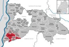
Location of Müllheim within Breisgau-Hochschwarzwald district 
 | ||
| Coordinates: 47°48′N 7°38′E / 47.800°N 7.633°ECoordinates: 47°48′N 7°38′E / 47.800°N 7.633°E | ||
| Country | Germany | |
| State | Baden-Württemberg | |
| Admin. region | Freiburg | |
| District | Breisgau-Hochschwarzwald | |
| Government | ||
| • Mayor | Astrid Siemes-Knoblich | |
| Area | ||
| • Total | 57.91 km2 (22.36 sq mi) | |
| Population (2013-12-31)[1] | ||
| • Total | 18,454 | |
| • Density | 320/km2 (830/sq mi) | |
| Time zone | CET/CEST (UTC+1/+2) | |
| Postal codes | 79371–79379 | |
| Dialling codes | 07631 | |
| Vehicle registration | FR | |
| Website | www.muellheim.de | |
Müllheim is a town in Baden-Württemberg in southern Germany. It belongs to the district Breisgau-Hochschwarzwald. Müllheim is generally considered to be the center of the region known as Markgräflerland.
History
On October 27, 758 Strachfried gave as a gift to the monastery of St. Gallen his properties in Müllheim, including the vineyards. This deed is in the archives of St. Gallen and it is where we today can find the first written reference to the "villa Mulinhaimo", which is the current city of Müllheim.
Archeology shows however that Müllheim was inhabited even earlier than this. During the renovation of the Martin's church in 1980 and 1981 the workers came upon a portion of a Roman villa. It is assumed that it is the center of large Roman possessions in the region.
Population
Inhabitants: 17,630 (February 2002) as follows - 12,030 Central Müllheim 1351 Hügelheim; 1235 Niederweiler; 991 Britzingen; 812 Vögisheim; 636 Feldberg; 362 Dattingen; 215 Zunzingen.
Geography
Müllheim is located in the center of Markgräflerland, in between the "Bath triangle" of Badenweiler, Bad Krozingen and Bad Bellingen. The city lies between the Rhine valley and the Black Forest with hills devoted largely to vineyards.
Müllheim is bordered by Auggen (to the south), Vögisheim to the southeast, and Hügelheim to the north. The main artery is the B3 which runs a north-south route along Müllheim's western side. It lies between Freiburg in the north and Basel, Switzerland to the south on this route.
Economy
Local jobs roughly. 8,000 of which about 3,000 are industrial, mainly work with glass, and metal.
Commuting:
- Incoming: about 4,000
- Outgoing: about 3,000
Education
General schools
- Michael-Friedrich-Wild-Grundschule
- Rosenburg Grundschule
- Grundschule Britzingen
- Adolf-Blankenhorn-Hauptschule
- Albert-Julius-Sievert-Förder- u. Sprachheilschule Heilpädagogisches Förderzentrum
- Alemannen-Realschule
- Markgräfler Gymnasium
- Freie Waldorfschule
Professional schools
- Georg-Kerschensteiner-Schule Gewerbliche Schulen
- House (Home economics) and agricultural Schools
- Commercial Schools
Miscellaneous schools
- Forum Jugend-Beruf
- Grundschulförderklasse
- Sprachheilkindergarten
Transportation
Müllheim has its own train stop on the Freiburg/Basel line, serviced by the Deutsche Bahn.
International relations
Twin towns – Sister cities
Müllheim is twinned with:
References
- ↑ "Gemeinden in Deutschland mit Bevölkerung am 31. Dezember 2013 (Einwohnerzahlen auf Grundlage des Zensus 2011)". Statistisches Bundesamt (in German). 2014.
- ↑ "Association Suisse des Communes et Régions d’Europe". L'Association suisse pour le Conseil des Communes et Régions d'Europe (ASCCRE) (in French). Retrieved 2013-07-20.
External links
| Wikimedia Commons has media related to Müllheim (Baden). |
- Official Web site (German)
- History and many images (German)
|
