Gwrtheyrnion

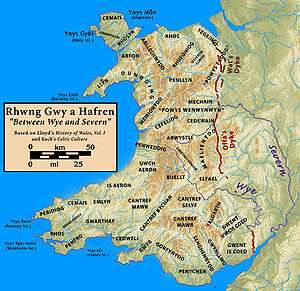
Gwrtheyrnion or Gwerthrynion was a commote in medieval Wales, located in Mid Wales on the north side of the River Wye. For most of the Middle Ages its rulers operated independently of other powers, but it was sometimes associated with the cantref of Maelienydd and the Kingdom of Powys, and, in the Norman era, with the region known as Rhwng Gwy a Hafren. It is said to have taken its name from the legendary king Vortigern (Welsh: Gwrtheyrn), and for a time was part of an independent regional kingdom.
Name and location
According to the 9th-century Historia Brittonum, Gwrtheyrnion, here Latinised Guorthegirnaim, was named for Vortigern (Welsh: Gwrtheyrn), a legendary 5th-century King of Britain.[1] John Edward Lloyd considers this derivation accurate.[2] Generally, its boundaries were the cantrefi of Arwystli to the north, Maelienydd (in its restricted sense) to the east, Elfael to the southeast, and Buellt to the southwest. It also controlled the commote of Cwmwd Deuddwr on the west of the Wye, together they formed a cantref.[3]
Around 800 Gwrtheyrnion formed part of a minor regional kingdom with Buellt, situated across the Wye.[4] Later medieval lists of commotes and cantrefs more generally associate it with territories on the north side of the Wye; some, but not all, tie it to the cantref of Maelienydd.[5] Others tie it instead to Arwystli, though this is evidently the result of a scribal error.[5] The historical centre of Gwrtheyrnion was Rhayader, from which it is thought the traditional county of Radnorshire was named.
History
The Historia Brittonum provides the earliest mention of Gwrtheyrnion. According to the text, Vortigern fled to the Gwrtheyrnion after Saint Germanus of Auxerre had castigated him for his various sins. He eventually died, and his son Pascent received Gwrtheyrnion and Buellt from Ambrosius Aurelianus.[6] Additionally, one of the text's copyists, from whose copy most other surviving manuscripts are derived, took particular interest in this kingdom, and introduced a passage on a certain Ffernfael, whose descent is traced back to Vortigern through Pascent.[4] This Ffernfael is also known from the genealogies from Jesus College MS 20. These indicate that his cousin Brawstudd married Arthfael Hen ap Rhys, who ruled Morgannwg in the early 9th century, implying a floruit for Ffernfael around that time.[4]
Gwrtheyrnion, along with the cantrefs of Elfael and Maelienydd, were for some time considered part of the Kingdom of Powys, though in the later Middle Ages Powys exerted no control over them.[5] The Historia genealogy is interesting in showing that the kings of Gwrtheyrnion themselves claimed no connection to the Powys dynasties, but instead traced their pedigree to the unrelated Vortigern.[5] By the time of Gerald of Wales the general area was known as Rhwng Gwy a Hafren (English: Between Wye and Severn), and was almost entirely independent of Powys.[7] After the Norman invasion Rhwng Gwy a Hafren was nominally in the hands of Norman Marcher Lords, but their control was often tenuous and Welsh lords periodically re-established dominance.[8]
In the 16th century Gwrtheyrnion and the rest of Rhwng Gwy a Hafren were reorganised into the county of Radnorshire by the Laws in Wales Acts. It is currently part of the modern county of Powys.
Notes
References
- Davies, R. R. (2000). The Age of Conquest: Wales, 1063-1415. Oxford University Press. ISBN 0-19-820878-2. Retrieved November 9, 2009.
- Lloyd, John Edward (1912). A History of Wales from the Earliest Times to the Edwardian Conquest. Longmans, Green, and Co. Retrieved November 6, 2009.
- Owen, George; Henry Owen (Ed.) (1892). The Description of Penbrokshire. C. K. Clark. Retrieved November 4, 2009. Cite uses deprecated parameter
|coauthors=(help)
| ||||||||||