Richat Structure


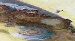
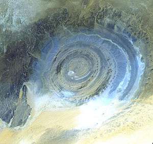
The Richat Structure, also known as the Eye of the Sahara and Guelb er Richat, is a prominent circular feature in the Sahara desert near Ouadane, west–central Mauritania. This structure is a deeply eroded, slightly elliptical, 40 km in diameter dome. The sedimentary rock exposed in this dome ranges in age from Late Proterozoic within the center of the dome to Ordovician sandstone around its edges. The sedimentary rocks comprising this structure dip outward at 10°–20°. Differential erosion of resistant layers of quartzite has created high-relief circular cuestas. Its center consists of a siliceous breccia covering an area that is at least 30 km in diameter.[1][2][3]
Exposed within the interior of the Richat Structure are a variety of intrusive and extrusive igneous rocks. They include rhyolitic volcanic rocks, gabbros, carbonatites and kimberlites. The rhyolitic rocks consist of lava flows and hydrothermally altered tuffaceous rocks that are part of two distinct eruptive centers, which are interpreted to be the eroded remains of two maars. According to field mapping and aeromagnetic data, the gabbroic rocks form two concentric ring dikes. The inner ring dike is about 20 m in width and lies about 3 km from the center of Richat Structure. The outer ring dike is about 50 m in width and lies about 7 to 8 km from the center of this structure. Thirty-two carbonatite dikes and sills have been mapped within the Richat Structure. The dikes are generally about 300 m long and typically 1 to 4 m wide. They consist of massive carbonatites that are mostly devoid of vesicles. The carbonatite rocks have been dated as having cooled between 94 to 104 million years ago. A kimberlitic plug and several sills have been found within the northern part of the Richat Structure. The kimberlite plug has been dated to around 99 million years old. These intrusive igneous rocks are interpreted as indicating the presence of a large alkaline igneous intrusion that currently underlies the Richat Structure and created it by uplifting the overlying rock.[1][2][4][5]
Spectacular hydrothermal features are a part of the Richat Structure. They include the extensive hydrothermal alteration of rhyolites and gabbros and a central megabreccia created by hydrothermal dissolution and collapse. The siliceous megabreccia is at least 40 m thick in its center to only a few meters thick along its edges. The breccia consists of fragments of white to dark gray cherty material, quartz-rich sandstone, diagenetic cherty nodules, and stromatolitic limestone and is intensively silicified. The hydrothermal alteration, which created this breccia, has been dated to have occurred about 98.2 ± 2.6 million years ago using the 40Ar/39Ar method.[1][2][5]
Initially interpreted as an asteroid impact structure because of its high degree of circularity, it is now argued to be a highly symmetrical and deeply eroded geologic dome. After extensive field and laboratory studies, geologists have not found any credible evidence for shock metamorphism or any type of deformation indicative of a hypervelocity extraterrestrial impact.[6] While coesite, an indicator of shock metamorphism, had initially been reported as being present in rock samples collected from the Richat Structure, further analysis of rock samples concluded that barite had been misidentified as coesite.[7] In addition, the Richat Structure lacks the annular depression that characterizes large extraterrestrial impact structures of this size. Also, it is quite different from large extraterrestrial impact structures in that the sedimentary strata comprising this structure is remarkably intact and "orderly" and lacking in overturned, steeply dipping strata or disoriented blocks.[1][2] A more recent multianalytical study on the Richat megabreccias concluded that carbonates within the silica-rich megabreccias were created by low-temperature hydrothermal waters, and that the structure requires special protection and further investigation of its origin.[8]
References
- 1 2 3 4 Matton, G. (2008) The Cretaceous Richat Complex (Mauritania); a peri-Atlantic alkaline. Unpublished PhD. dissertation, Universite du Quebec a Chicoutimi, Chicoutimi, Quebec, Canada.
- 1 2 3 4 Matton, G., M. Jébrak and J.K.W. Lee (2005) Resolving the Richat enigma: Doming and hydrothermal karstification above an alkaline complex. Geology. v. 33, no. 8, pp. 665-668.
- ↑ Woolley, A.R. (2001) Alkaline Rocks and Carbonatites of the World, Part 3: Africa. London, United Kingdom, The Geological Society of London. ISBN 978-0-412-61410-1
- ↑ Netto, A.M., J. Fabre, J., G. Poupeau, and M. et Champemmois (1992) Datations par traces de fissions de la structure circulaire des Richats.Comptes Rendus de 'Académie des Sciences. v. 314, pp. 1179-1186.
- 1 2 Matton, G., and M. Jébrak (2014) The ‘‘eye of Africa’’ (Richat dome, Mauritania): An isolated Cretaceous alkaline–hydrothermal complex Journal of African Earth Sciences. v. 97, no. 8, pp. 109–124.
- ↑ Dietz, R.S., R. Fudali, and W. Cassidy (1969) Richat and Semsiyat Domes (Mauritania): Not Astroblemes. Geological Society of America. v. 80, no. 7, pp. 1367-1372.
- ↑ Fudali, R. F. (1969) Coesite from the Richat Dome, Mauritania: A Misidentification. Science. v. 166, no. 3902, pp. 228-230.
- ↑ Martinez-Frias, J., Rull, F., Martín-Redondo, M.P., Delgado, A., Fernández-Sampedro, M.T., García-Talavera, F., López-Vera, F. and Menor Salván, C.(2011) Multianalytical characterization of silica-rich megabreccias from the proposed natural area of Richat (Sahara desert, Mauritania). Research Journal of Chemistry and Environment v. 15, no. 3, pp. 49-54.
External links
| Wikimedia Commons has media related to Richat Structure. |
- Anonymous (nd) Richat Structure, Mauritania NASA Earth Observatory
- Anonymous (nd) Earth’s Bulls-Eye, the Eye of Africa, Landmark for Astronauts. Love These Pics
- Nemiroff, R., and J. Bonnell (2002) Earth's Richat Structure, Astronomy Picture of the Day, October 28, 2002. Astronomy Picture of the Day, Michigan Technological University, Houghton, Michigan.
- Découverte - L'énigme de Richat (French), A video documentary from Radio Canada.
Coordinates: 21°07′26″N 11°24′07″W / 21.124°N 11.402°W