Guaimbê
| Guaimbê | |
|---|---|
| Municipality | |
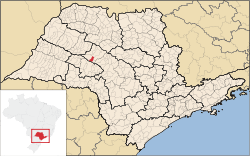
 Location in São Paulo state | |
 Guaimbê Location in Brazil | |
| Coordinates: 21°54′36″S 49°53′48″W / 21.91000°S 49.89667°WCoordinates: 21°54′36″S 49°53′48″W / 21.91000°S 49.89667°W | |
| Country |
|
| Region | Southeast Region |
| State | São Paulo |
| Area | |
| • Total | 218 km2 (84 sq mi) |
| Population (2015) | |
| • Total | 5,696 |
| • Density | 26/km2 (68/sq mi) |
| Time zone | BRT/BRST (UTC-3/-2) |
Guaimbê is a municipality in the state of São Paulo in Brazil. It is located near the cities of Lins and Araçatuba. It was founded in 1953. The population is 5,696 (2015 est.) in an area of 218 km².[1] Its altitude is 469 m.
Guaimbê or guaibê is also a plant (Philodendron williamsii) which has a sweet fruit which was very much appreciated by the Guarani Indians. The location was probably named after the plant.
References
| ||||||||||||||||||||||||||||||||||||||||||||||||||||||||||||||||||||
This article is issued from Wikipedia - version of the Sunday, November 08, 2015. The text is available under the Creative Commons Attribution/Share Alike but additional terms may apply for the media files.