Grenada, Mississippi
| Grenada, Mississippi | |
|---|---|
| City | |
 | |
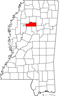
 Location of Grenada, Mississippi | |
 Grenada, Mississippi Location in the United States | |
| Coordinates: 33°46′30″N 89°48′32″W / 33.77500°N 89.80889°WCoordinates: 33°46′30″N 89°48′32″W / 33.77500°N 89.80889°W | |
| Country | United States |
| State | Mississippi |
| County | Grenada |
| Area | |
| • Total | 30.0 sq mi (77.6 km2) |
| • Land | 30.0 sq mi (77.6 km2) |
| • Water | 0.0 sq mi (0.0 km2) |
| Elevation | 213 ft (65 m) |
| Population (2010)[1] | |
| • Total | 13,092 |
| • Density | 440/sq mi (170/km2) |
| Time zone | Central (CST) (UTC-6) |
| • Summer (DST) | CDT (UTC-5) |
| ZIP codes | 38901-38902 |
| Area code(s) | 662 |
| FIPS code | 28-29460 |
| GNIS feature ID | 0670734 |
Grenada is a city in Grenada County, Mississippi, United States. The population was 13,092 at the 2010 census. It is the county seat of Grenada County.[2]
History
Grenada was formed in 1836, after removal of the historic Native Americans of the area, via the union of the two adjacent towns (separated by the present-day Line Street) of Pittsburg and Tulahoma, founded respectively by European Americans Franklin Plummer and Hiram Runnels.[3] Development included stores and businesses that supported the county court and market days. County riverfront plantations were developed largely for cotton as a commodity crop.


In December 1862, Confederate general Earl Van Dorn, whose troops had been encamped in Grenada, led the three brigades under his command in an attempt to destroy the Union supply depot at Holly Springs, Mississippi.[4]
In 1851 townspeople founded the Yalobusha Baptist Female Institute for education of their young women. In 1882 it was taken over by the Methodists and renamed as Grenada College.[3] Classified in the 20th century as a junior college, it encountered financial troubles during the Great Depression. The church closed the college in 1936 and transferred its assets to Millsaps College.[5]
In the civil rights era, national legislation was passed to enforce the constitutional rights of African Americans. In 1966, James Meredith's March against Fear passed through Grenada on the way to Jackson. He wanted to encourage voter registration following passage the previous year of the Voting Rights Act. The town officials appeared cooperative, protecting the marchers and hiring six black registrars, who registered one thousand black residents to vote. But, after the march passed through, the county fired the registrars. It was revealed that the 1,000 new black voters were never entered on official rolls.[6] The marchers, including Martin Luther King and Dick Gregory, spent about a week demonstrating in Grenada before moving on.[7]
In 1966 and 1967, the Southern Christian Leadership Conference ran a civil rights organizing project in Grenada which lasted at least 11 months.[8] They worked to register voters and gain concessions for hiring African Americans in local businesses and restaurants, which had been segregated.
Geography
Grenada is located at 33°46′30″N 89°48′32″W / 33.77500°N 89.80889°W (33.775080, -89.808768).[9] It is situated on the south bank of the Yalobusha River. Grenada Lake is located a short distance from the city. Grenada Lake is a man made lake that falls under the supervision of the Army Corp of Engineers.
According to the United States Census Bureau, the city has a total area of 30.0 square miles (78 km2), of which, 30.0 square miles (78 km2) is land and 0.03% is water.
Demographics
| Historical population | |||
|---|---|---|---|
| Census | Pop. | %± | |
| 1870 | 1,887 | — | |
| 1880 | 1,914 | 1.4% | |
| 1890 | 2,416 | 26.2% | |
| 1900 | 2,568 | 6.3% | |
| 1910 | 2,814 | 9.6% | |
| 1920 | 3,402 | 20.9% | |
| 1930 | 4,349 | 27.8% | |
| 1940 | 5,831 | 34.1% | |
| 1950 | 7,388 | 26.7% | |
| 1960 | 794 | −89.3% | |
| 1970 | 9,944 | 1,152.4% | |
| 1980 | 11,508 | 15.7% | |
| 1990 | 10,864 | −5.6% | |
| 2000 | 14,879 | 37.0% | |
| 2010 | 13,092 | −12.0% | |
| Est. 2014 | 12,956 | [10] | −1.0% |

As of the census[12] of 2000, there were 14,879 people, 5,701 households, and 3,870 families residing in the city. The population density was 496.8 people per square mile (191.8/km²). There were 6,210 housing units at an average density of 207.3 per square mile (80.1/km²). The racial makeup of the city was 49.28% White, 49.34% African American, 0.16% Native American, 0.50% Asian, 0.02% Pacific Islander, 0.12% from other races, and 0.56% from two or more races. Hispanic or Latino of any race were 0.70% of the population.
There were 5,701 households out of which 33.4% had children under the age of 18 living with them, 41.9% were married couples living together, 22.2% had a female householder with no husband present, and 32.1% were non-families. 28.3% of all households were made up of individuals and 12.1% had someone living alone who was 65 years of age or older. The average household size was 2.52 and the average family size was 3.10.
In the city the population was spread out with 27.5% under the age of 18, 9.4% from 18 to 24, 26.7% from 25 to 44, 20.5% from 45 to 64, and 15.9% who were 65 years of age or older. The median age was 35 years. For every 100 females there were 82.5 males. For every 100 females age 18 and over, there were 76.5 males.
The median income for a household in the city was $25,589, and the median income for a family was $31,316. Males had a median income of $27,946 versus $21,913 for females. The per capita income for the city was $13,734. About 20.3% of families and 23.6% of the population were below the poverty line, including 30.1% of those under age 18 and 27.3% of those age 65 or over.
Notable people

- Phillip Alford, child actor (To Kill a Mockingbird, Shenandoah), resident businessman.
- Chris Avery, professional football player, born in Grenada.
- Pete Boone, University of Mississippi athletic director, born in Grenada.
- Ace Cannon, musician.
- Walter Davis, blues musician.
- Jake Gibbs, baseball player, All American football player.
- George Robert Hightower, educator.
- M. D. Jennings, football player.
- Mississippi John Hurt, blues folk musician, died in Grenada.
- Trent Lott, U.S. senator, born in Grenada.
- Jim Miles, baseball player.
- Ike Pearson, baseball player.
- Freeman Ransom, lawyer, businessman, and civic activist.
- Magic Slim, blues musician.
- Magic Sam, blues musician, born in Grenada.
- Joseph D. Sayers, 22nd Governor of Texas.
- Homer Spragins, baseball player.
- Trumaine Sykes, pro football player.
- Greg Robinson, pro football player, born in Grenada.
- Donna Tartt, author.
- Edward C. Walthall, United States senator.
- Howard Waugh, Canadian football player and humanitarian.
- Eddie Willis, member of Funk Brothers, born in Grenada.
- William Winter, former governor of Mississippi.
- Charlie Worsham, country singer, musician, and songwriter
- Frank Wright, jazz musician.
Education
The City of Grenada, as well as Grenada County, is served by the Grenada School District. Kirk Academy, a private K-12 school, is also located in Grenada.
See also
- Billups Neon Crossing Signal A unique railroad crossing signal erected in Grenada.
References
- ↑ "2010 City Population and Housing Occupancy Status". U.S. Census Bureau. Retrieved May 14, 2012.
- ↑ "Find a County". National Association of Counties. Retrieved 2011-06-07.
- 1 2 Federal Writers' Project. Mississippi: A Guide to the Magnolia State. US History Publishers. p. 383. ISBN 978-1-60354-023-0. Retrieved 24 July 2012.
- ↑ David Stephen Heidler; Jeanne T. Heidler; David J. Coles (1 September 2002). Encyclopedia of the American Civil War: A Political, Social, and Military History. W. W. Norton & Company. p. 987. ISBN 978-0-393-04758-5. Retrieved 23 July 2012.
- ↑ J. C. Hathorn. A History of Grenada County. David Jensen. p. 55. Retrieved 24 July 2012.
- ↑ Robert Analavage (August 1966). "Which way in Grenada". The Southern Patriot. reprinted in Clayborne Carson; et al. (2003). Reporting Civil Rights: American Journalism, 1963-1973. Library of America. pp. 516–9. Retrieved 22 July 2012.
- ↑ Society of Former Special Agents of the FBI. Turner Publishing Company. 15 June 1998. p. 65. ISBN 978-1-56311-473-1. Retrieved 23 July 2012.
- ↑ David Garrow (6 January 2004). Bearing the Cross: Martin Luther King, Jr., and the Southern Christian Leadership Conference. HarperCollins. p. 563. ISBN 978-0-06-056692-0. Retrieved 23 July 2012.
- ↑ "US Gazetteer files: 2010, 2000, and 1990". United States Census Bureau. 2011-02-12. Retrieved 2011-04-23.
- ↑ "Annual Estimates of the Resident Population for Incorporated Places: April 1, 2010 to July 1, 2014". Retrieved June 4, 2015.
- ↑ "Census of Population and Housing". Census.gov. Retrieved June 4, 2015.
- ↑ "American FactFinder". United States Census Bureau. Retrieved 2008-01-31.
| |||||||||||||||||||||

