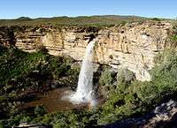
Namaqualand

.jpg)
Namaqualand (Afrikaans: Namakwaland) is an arid region of Namibia and South Africa, extending along the west coast over 1,000 kilometres (600 mi) and covering a total area of 440,000 square kilometres (170,000 sq mi). It is divided by the lower course of the Orange River into two portions – Little Namaqualand to the south and Great Namaqualand to the north. Little Namaqualand is within the Namakwa District Municipality and forms part of Northern Cape Province, South Africa. A typical municipality is Kamiesberg Local Municipality. Great Namaqualand is in the Karas Region of Namibia. Great Namaqualand is sparsely populated by the Namaqua, a Khoikhoi people who traditionally inhabited the Namaqualand region.
Some of the more prominent towns in this area are Springbok, being the capital of this region, as well as Kleinzee and Koiingnaas, both private mining towns owned by De Beers Diamond Mines. This area is quite rich in alluvial diamonds deposited along the coast by the Orange River. Oranjemund is another mining town along this coast, situated in Namibia, but very much on the border. As the name suggests, it is at the mouth of the Orange River which forms the border between South Africa and Namibia. The town of Alexander Bay is located 5 kilometres (3.1 mi) away opposite the river on the South African side and is linked to Oranjemund by the Ernest Oppenheimer Bridge. Other links crossing the river further upstream are a reintroduced pontoon at Sendelingsdrift in the Richtersveld National Park, and road bridges at Vioolsdrif (the main border crossing between the two countries) and at the remote border crossing of Onseepkans.
A vibrant fishing industry is found along this stretch of the South African west coast, especially in Port Nolloth, the major resort town of Namaqualand, and Hondeklipbaai, or Dogstonebay, called such because of a large boulder outside the town which, when viewed correctly, looks vaguely like a dog sitting down. Since the 19th century, copper has been mined at Springbok and its surrounding towns, while a large mine extracting copper, lead, zinc, and silver is located at Aggeneys, 110 kilometres (70 mi) further inland.
Namaqualand is quite popular with both local and international tourists during early springtime, when for a short period this normally arid area becomes covered with a kaleidoscope of colour during the flowering season. This is known throughout South Africa as the Namaqualand daisy season, when orange and white daisies, as well as hundreds of other flowering species, spring up from a previously barren landscape. A part of Little Namaqualand, known as the Richtersveld, is a national park and a World Heritage Site, while the often-visited Namaqua National Park and the Goegap Nature Reserve are located short distances from Kamieskroon and Springbok, respectively.
As a region, it has one of the highest percentages of Afrikaans speakers in the world, with over 95% of the population speaking the Afrikaans language. The original Khoekhoe language of the Nama people, with its intricate system of click sounds, also still survives in remote areas.
See also


References
- ↑ "A School in Namacqualand, Southern Africa". Wesleyan Juvenile Offering (London: Wesleyan Mission House) XXII: 120. August 1865. Retrieved 1 December 2015.
External links
| Wikimedia Commons has media related to Namaqualand. |