Brick Lane Mosque
| Brick Lane Jamme Masjid | |
|---|---|
| | |
| Location | Brick Lane, Tower Hamlets, London, United Kingdom |
| Established | 1743 (built), 1976 (mosque) |
| Branch/tradition | Sunni – Fultali |
| Leadership | Imam(s): Maulana Nazrul Islam Chairman: Al-Haj Sajjad Miah |
| Architectural information | |
| Style | Georgian architecture |
| Capacity | 3000 |
| Minaret(s) | 1 |
|
| |
| Website: bricklanejammemasjid | |
Brick Lane Jamme Masjid (Bengali: ব্রিক লেন জামে মসজিদ "Brick Lane Great Mosque"), formerly known as the London Jamme Masjid (লন্ডন জামে মসজিদ "London Great Mosque"), is located in the area of Spitalfields alongside the street of Brick Lane and Fournier Street in east London, England. The majority of worshippers of the mosque are of Bangladeshi descent; the mosque serves the largest concentration of Bangladeshi Muslims in the country. The building at 59 Brick Lane previously served the religions of a succession of other communities in the area. Built during the 18th century, it is one of the oldest buildings in East London which still stands today.[1]
The mosque can hold up to 3000 people[2] and is most crowded during the jummah prayers on Friday.[1] All sermons are delivered in Sylheti Bengali. In terms of beliefs and practices, the mosque follows the traditions of the controversial Sayyid Ahmad of Balakot. The mosque has close links with the Bangladesh Welfare Association, which addresses social and community needs.[3][4] Arabic and mother tongue classes are available for children on the top floors.
History
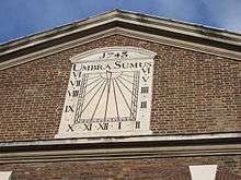
The building was first established in 1743 as a Protestant chapel ("La Neuve Eglise") by London's French Huguenot community.[5] These Huguenots were refugees who had left France to escape persecution from the Catholics. The building survived as a Huguenot chapel for more than six decades. In 1809 it became a Wesleyan chapel, bought by the London Society for Promoting Christianity Amongst the Jews (an organisation now known as the Church's Ministry Among Jewish People), but this phase of its history lasted only 10 years. From 1819, the building became a Methodist chapel.[6]
In the late 19th century, the building at 59 Brick Lane was adopted by yet another community. It became the Machzike Hadath, the Spitalfields Great Synagogue. During this time, the area was home to many Jewish refugees from Russia and Central Europe.[7] The population of Jews decreased over the years, with many moving to areas of North London. The synagogue eventually moved to new premises in Golders Green.[8]
During the 1970s, the area of Spitalfields and Brick Lane was populated mainly by Bangladeshis who had come to Britain from the Sylhet region looking for better work. Many found work in factories and the textile trade. That growing community required a place of worship, and the building at 59 Brick Lane was bought and refurbished. In 1976, it reopened as a mosque, the London Jamme Masjid. Today, although it has been renamed, it still serves the Bangladeshi community as a mosque.[1]
The former 'Great Synagogue' in Fournier Street is a Grade II* listed building;[9] the adjacent former school buildings (now used as an ancillary building to the mosque) is listed Grade II.[10]

See also
- Brick Lane
- Islam in the United Kingdom
- Islam in London
- List of mosques
- East London Mosque
- British Bangladeshi
References
- 1 2 3 59 Brick Lane: a History Icons of England. Retrieved on 2009-04-27.
- ↑ Muslim Directory
- ↑ David Garbin (June 2005) Bangladeshi diaspora in the UK: some observations on socio-cultural dynamics, religious trends and transnational politics University of Surrey. Retrieved on 2009-04-27.
- ↑ Ira Marvin Lapidus (2002). A history of Islamic societies. Cambridge University Press. p. 799. ISBN 978-0-521-77933-3.
- ↑ Richard Jones (2006). Frommer's Memorable Walks in London. John Wiley and Sons. p. 93. ISBN 978-0-471-77338-2
- ↑ Rob Humphreys, Judith Bamber (2003). London. Rough Guides. p. 238. ISBN 978-1-84353-093-0
- ↑ John Eade, Dyab Abou Jahjah, Saskia Sassen (2004). Identities on the Move. Counterpoint. p. 16. ISBN 978-0-86355-531-2
- ↑ http://machzikehadath.com/history/
- ↑ Historic England. "Details from image database (205992)". Images of England. accessed 8 August 2009
- ↑ Historic England. "Details from image database (205792)". Images of England. accessed 8 August 2009
Coordinates: 51°31′9.6″N 0°4′20″W / 51.519333°N 0.07222°W
| Wikimedia Commons has media related to Brick Lane Mosque. |
