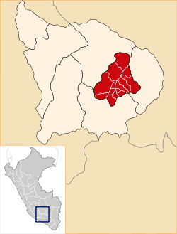
Grau Province
| Grau | |
|---|---|
| Province | |
 Location of Grau in the Apurímac Region | |
| Country | Peru |
| Region | Apurímac |
| Capital | Chuquibambilla |
| Area | |
| • Total | 2,174.52 km2 (839.59 sq mi) |
| Population | |
| • Total | 27,574 |
| • Density | 13/km2 (33/sq mi) |
| UBIGEO | 0307 |
Grau Province is one of the seven provinces of the Apurímac Region in Peru. The capital of the province is the city of Chuquibambilla.
The province was named after the naval officer Miguel Grau Seminario.
Boundaries
- North: Abancay Province
- East: Cotabambas Province
- South: Antabamba Province
- West: Abancay Province
Political division
The province measures 2,174.52 square kilometres (839.59 sq mi) and is divided into fourteen districts:
- Chuquibambilla
- Curasco
- Curpahuasi
- Huayllati
- Mamara
- Mariscal Gamarra
- Micaela Bastidas
- Pataypampa
- Progreso
- San Antonio
- Santa Rosa
- Turpay
- Vilcabamba
- Virundo
Ethnic groups
The people in the province are mainly indigenous citizens of Quechua descent. Quechua is the language which the majority of the population (81.28%) learnt to speak in childhood, 18.17% of the residents started speaking using the Spanish language and 0.22% using Aymara (2007 Peru Census).[1]
See also
Sources
- ↑ inei.gob.pe INEI, Peru, Censos Nacionales 2007
| ||||||
Coordinates: 14°06′50″S 72°42′54″W / 14.11389°S 72.71500°W
This article is issued from Wikipedia - version of the Friday, October 30, 2015. The text is available under the Creative Commons Attribution/Share Alike but additional terms may apply for the media files.