Grandville, Michigan
| Grandville, Michigan | |
|---|---|
| City | |
|
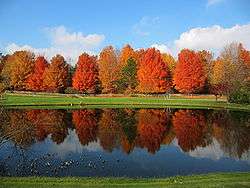
A pond fronting a forest of maple trees in Grandville. | |
| Motto: "Charting New Courses..." [1] | |
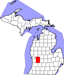
 Location of Grandville, Michigan | |
| Coordinates: 42°54′14″N 85°45′27″W / 42.90389°N 85.75750°W | |
| Country | United States |
| State | Michigan |
| County | Kent |
| Area[2] | |
| • Total | 7.67 sq mi (19.87 km2) |
| • Land | 7.27 sq mi (18.83 km2) |
| • Water | 0.40 sq mi (1.04 km2) |
| Elevation | 604 ft (184 m) |
| Population (2010)[3] | |
| • Total | 15,378 |
| • Estimate (2014[4]) | 15,857 |
| • Density | 2,115.3/sq mi (816.7/km2) |
| Time zone | Eastern (EST) (UTC-5) |
| • Summer (DST) | EDT (UTC-4) |
| ZIP codes | 49418, 49468 |
| Area code(s) | 616 |
| FIPS code | 26-34160[5] |
| GNIS feature ID | 0627126[6] |
| Website | The City of Grandville, Michigan |
Grandville is a city in Kent County in the U.S. state of Michigan. The population was 15,378 at the 2010 census and is part of the Grand Rapids metropolitan area. Grandville is one of the oldest suburbs of Grand Rapids, and was incorporated as a city in 1933.
History
Grandville was geographically an important place during the logging years in Michigan's history due to its location at the "river-bend" of the Grand River. It was important to have people there to make sure the logs did not jam up as the river turned north-west toward Grand Haven.
Geography
According to the United States Census Bureau, the city has a total area of 7.67 square miles (19.87 km2), of which, 7.27 square miles (18.83 km2) is land and 0.40 square miles (1.04 km2) is water.[2]
Grandville is located near the southwest corner of Grand Rapids. The western border of the city of Grandville is also the western border of Kent County, marked by Kenowa Avenue; this is where Ottawa County and Jenison begin. To the east and south of Grandville lies the city of Wyoming. The city of Walker lies just north of Grandville.
Demographics
| Historical population | |||
|---|---|---|---|
| Census | Pop. | %± | |
| 1880 | 548 | — | |
| 1900 | 457 | — | |
| 1910 | 680 | 48.8% | |
| 1920 | 799 | 17.5% | |
| 1930 | 1,346 | 68.5% | |
| 1940 | 1,566 | 16.3% | |
| 1950 | 2,022 | 29.1% | |
| 1960 | 7,975 | 294.4% | |
| 1970 | 10,764 | 35.0% | |
| 1980 | 12,412 | 15.3% | |
| 1990 | 15,624 | 25.9% | |
| 2000 | 16,263 | 4.1% | |
| 2010 | 15,378 | −5.4% | |
| Est. 2014 | 15,857 | [7] | 3.1% |
2010 census
As of the census[3] of 2010, there were 15,378 people, 5,982 households, and 4,160 families residing in the city. The population density was 2,115.3 inhabitants per square mile (816.7/km2). There were 6,276 housing units at an average density of 863.3 per square mile (333.3/km2). The racial makeup of the city was 92.0% White, 2.2% African American, 0.2% Native American, 1.5% Asian, 1.8% from other races, and 2.4% from two or more races. Hispanic or Latino of any race were 6.2% of the population. There were 5,982 households of which 33.5% had children under the age of 18 living with them, 54.5% were married couples living together, 11.0% had a female householder with no husband present, 4.1% had a male householder with no wife present, and 30.5% were non-families. 24.9% of all households were made up of individuals and 10.2% had someone living alone who was 65 years of age or older. The average household size was 2.54 and the average family size was 3.06.
The median age in the city was 36.3 years. 24.8% of residents were under the age of 18; 9.7% were between the ages of 18 and 24; 25.3% were from 25 to 44; 25.6% were from 45 to 64; and 14.6% were 65 years of age or older. The gender makeup of the city was 48.3% male and 51.7% female.
Arts and culture
Points of interest
- RiverTown Crossings is the largest shopping mall in the Grand Rapids area.
Notable people
- David Agema, Michigan state representative
- Allyssa DeHaan, collegiate basketball player
- Brent Gates, professional baseball player
- Terri Lynn Land, Michigan Secretary of State
- Benny McCoy, professional baseball player
- Dave Walsh, professional Halo 2 player
Infrastructure
Major highways
References
- ↑ "The City of Grandville, Michigan". The City of Grandville, Michigan. Retrieved August 26, 2012.
- 1 2 "US Gazetteer files 2010". United States Census Bureau. Retrieved 2012-11-25.
- 1 2 "American FactFinder". United States Census Bureau. Retrieved 2012-11-25.
- ↑ "Population Estimates". United States Census Bureau. Retrieved 2013-06-03.
- ↑ "American FactFinder". United States Census Bureau. Retrieved 2008-01-31.
- ↑ "US Board on Geographic Names". United States Geological Survey. 2007-10-25. Retrieved 2008-01-31.
- ↑ "Annual Estimates of the Resident Population for Incorporated Places: April 1, 2010 to July 1, 2014". Retrieved June 4, 2015.
- ↑ "Census of Population and Housing". Census.gov. Retrieved June 4, 2015.
External links
| Wikimedia Commons has media related to Grandville, Michigan. |
- Grandville official website
- www.city-data.com Grandville Information
- Grandville 2010 census data
- Grandville community profile
| |||||||||||||||||||||||||||||||||||||
Coordinates: 42°54′35″N 85°45′47″W / 42.90972°N 85.76306°W

