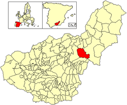
Gor, Granada
| Gor | |||
|---|---|---|---|
| Municipality | |||
| |||
 Location of Gor | |||
 Gor Location in Spain | |||
| Coordinates: 37°22′N 2°58′W / 37.367°N 2.967°WCoordinates: 37°22′N 2°58′W / 37.367°N 2.967°W | |||
| Country |
| ||
| Autonomous community |
| ||
| Province | Granada | ||
| Comarca | Comarca de Guadix | ||
| Judicial district | Guadix | ||
| Government | |||
| • Alcalde | Francisco Porcel Gómez (2007) (PP) | ||
| Area | |||
| • Total | 182 km2 (70 sq mi) | ||
| Elevation | 1,238 m (4,062 ft) | ||
| Population (2008) | |||
| • Total | 940 | ||
| • Density | 5.2/km2 (13/sq mi) | ||
| Demonym(s) | Goreño/a | ||
| Time zone | CET (UTC+1) | ||
| • Summer (DST) | CEST (UTC+2) | ||
| Postal code | 18870 | ||
| Website | Official website | ||
Gor is a town of Granada, in southwestern Spain. It consists of the town center and several suburbs scattered all over its municipal area, such as Las Juntas, Las Viñas, Cenascuras, Los Balcones, La Rambla Valdiquín, Los corrales, El Royo Serval and La Estación de Gorafe. Situated at an altitude of between 1,100 m and 2,100 m above sea level and with an extension of 182 km², Gor has a long history of human settlements that date back to the Paleolithic. The official population of Gor in 2005 was 997.
External links
This article is issued from Wikipedia - version of the Sunday, May 31, 2015. The text is available under the Creative Commons Attribution/Share Alike but additional terms may apply for the media files.
.svg.png)
.svg.png)