Gooseberry Falls State Park
| Gooseberry Falls State Park | |
| Minnesota State Park | |
| Upper Gooseberry Falls. | |
| Country | |
|---|---|
| State | |
| County | Lake |
| Location | Two Harbors |
| - elevation | 833 ft (254 m) [1] |
| - coordinates | 47°08′49″N 91°27′48″W / 47.14694°N 91.46333°WCoordinates: 47°08′49″N 91°27′48″W / 47.14694°N 91.46333°W |
| Area | 1,687 acres (683 ha) |
| Founded | 1937 |
| Management | Minnesota Department of Natural Resources |
|
Location of Gooseberry Falls State Park in Minnesota
| |
Gooseberry Falls State Park is a state park of Minnesota, USA, on the North Shore of Lake Superior. The park is located in Silver Creek Township, about 13 miles (21 km) northeast of Two Harbors, Minnesota in Lake County on scenic Minnesota Highway 61. The Joseph N. Alexander visitor center, built in 1996, provides space for interpretive displays, a cinema screening room, and a gift shop.

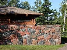
The rustic style resources in Gooseberry Falls State Park were constructed by the Civilian Conservation Corps between 1934 and 1941. The structures are notable for their stone construction, using red, blue, brown, and black basalt. The designs were supervised by the Minnesota Central Design Office of the National Park Service and construction was supervised by two Italian stonemasons.
The park provides 70 non-electric camping sites that are available year-round. There are 18 miles (29 km) of hiking trails, including 8 miles (13 km) of mountain bike trails. The trails connect to the Superior Hiking Trail.
References
- ↑ "Gooseberry Falls State Park". Geographic Names Information System. United States Geological Survey. 1980-01-11. Retrieved 2011-02-24.
External links
| Wikimedia Commons has media related to Gooseberry Falls State Park. |
| ||||||||||||||||||||||||||