Goodland Municipal Airport
| Goodland Municipal Airport Renner Field | |||||||||||||||||||
|---|---|---|---|---|---|---|---|---|---|---|---|---|---|---|---|---|---|---|---|
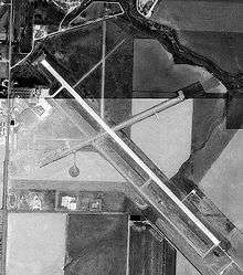
 USGS aerial image, 28 August 1991 | |||||||||||||||||||
| IATA: GLD – ICAO: KGLD – FAA LID: GLD | |||||||||||||||||||
| Summary | |||||||||||||||||||
| Airport type | Public | ||||||||||||||||||
| Owner | City of Goodland | ||||||||||||||||||
| Serves | Goodland, Kansas | ||||||||||||||||||
| Elevation AMSL | 3,656 ft / 1,114 m | ||||||||||||||||||
| Coordinates | 39°22′14″N 101°41′56″W / 39.37056°N 101.69889°W | ||||||||||||||||||
| Runways | |||||||||||||||||||
| |||||||||||||||||||
| Statistics (2007) | |||||||||||||||||||
| |||||||||||||||||||
Goodland Municipal Airport (IATA: GLD, ICAO: KGLD, FAA LID: GLD) (Renner Field) is two miles north of Goodland, in Sherman County, Kansas.[1]
Facilities
The airport covers 372 acres (151 ha) at an elevation of 3,656 feet (1,114 m). It has three runways: 12/30 is 5,499 by 100 feet (1,676 x 30 m) concrete; 5/23 is 3,501 by 75 feet (1,067 x 23 m) asphalt; 17/35 is 1,800 by 40 feet (549 x 12 m) turf.[1]
In the year ending July 16, 2007 the airport had 43,000 aircraft operations, average 117 per day: 98% general aviation, 1% air taxi and 1% military. 22 were then aircraft based at the airport: 77% single-engine and 23% multi-engine.[1]
History
Provided contract glider training to the United States Army Air Forces, 1942-1943. Training provided by William A. Ong under AAFTC 22d Glider Training Detachment. Used primarily C-47 Skytrains and Waco CG-4 unpowered Gliders. Training began on 8 June 1942. The mission of the school was to train glider pilot students in proficiency in operation of gliders in various types of towed and soaring flight, both day and night, and in servicing of gliders in the field.
During wartime the airport had four compacted soil runways; aligned N/S; NE/SW; E/W and NW/SE, all about 2,800' long with NE/SW 3,600' long. Former NW/SE runway now paved and used as main, others still visible in aerial photography. Training ended on 29 August 1943 due to shortage of equipment. Glider training mission was taken over by I Troop Carrier Command, and the airport was used as an axillary airfield until the end of the war. Was returned to civil control in September 1945.
Goodland Municipal had scheduled airline service on Air Midwest to Denver, Colorado's Stapleton International Airport in the 1980s.[2][3]
See also
References
- 1 2 3 4 FAA Airport Master Record for GLD (Form 5010 PDF), effective 2009-07-02.
- ↑ Braniff - September 1, 1989 Timetable, Departed Flights, Retrieved 2013-05-01
- ↑ Air Midwest - February 15, 1986 System Timetable, Departed Flights, Retrieved 2013-05-01
| Wikimedia Commons has media related to Renner Field (Airfield). |
Other sources
-
 This article incorporates public domain material from websites or documents of the Air Force Historical Research Agency.
 - Shaw, Frederick J. (2004), Locating Air Force Base Sites History’s Legacy, Air Force History and Museums Program, United States Air Force, Washington DC, 2004.
- Manning, Thomas A. (2005), History of Air Education and Training Command, 1942-2002. Office of History and Research, Headquarters, AETC, Randolph AFB, Texas ASIN: B000NYX3PC
External links
- Aerial photo as of 28 August 1991 from USGS The National Map
- FAA Airport Diagram (PDF), effective January 7, 2016
- FAA Terminal Procedures for RNV, effective January 7, 2016
- Resources for this airport:
- FAA airport information for RNV
- AirNav airport information for RNV
- FlightAware airport information and live flight tracker
- SkyVector aeronautical chart for RNV
| ||||||||||||||||||
