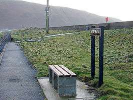
Golf Halt railway station
| Golf Halt | |
|---|---|
 | |
| Location | |
| Place | Fairbourne |
| Area | Gwynedd |
| Grid reference | SH610135 |
| Operations | |
| Operated by | Fairbourne Railway |
| Platforms | 1 |
| Stations on heritage railways in the United Kingdom | |
| A B C D E F G H I J K L M N O P Q R S T U V W X Y Z | |
| UK Railways portal | |
Golf Halt is a small railway halt on the Fairbourne Railway in Gwynedd, North Wales.
Until 2007 the station was known as Gorsafawddacha'idraigodanheddogleddollônpenrhynareurdraethceredigion (Welsh pronunciation: [ˌɡɔrsaˌvauðaχaɪˌdraɪɡɔˌdanhɛðˌɔɡlɛðɔˌɬoːnpɛnˌr̥ɪnarˌɛɨrˌdraːɨθkɛrɛˈdɪɡjɔn].
Overview
The name was contrived by the railway for publicity and to outdo Llanfairpwllgwyngyllgogerychwyrndrobwllllantysiliogogogoch. The Welsh name is translated as: "the Mawddach station and its dragon under the northern peace of the Penrhyn Road on the golden beach of Cardigan Bay."
The "dragon" refers to some surviving World War II anti-tank blocks, which have been said to look like dragon teeth.

On the Ordnance Survey OS Explorer map covering the region, the station is marked as "Golf Halt".
Problems with the name are the need for the apostrophe and that the two words ...[g]ogleddol-lôn... need a hyphen between them to make sense. Ll is a letter in its own right in Welsh. It also includes the description ar eurdraeth Ceredigion for "on the golden beach of Cardigan Bay": however "Cardigan Bay" is Bae Ceredigion, and it is the neighbouring county (the station itself is in Gwynedd). Possibly because of this, the name has not received much if any official recognition and Llanfairpwllgwyngyllgogerychwyrndrobwllllantysiliogogogoch is still regarded as the longest by most authorities. The station reverted to its original name of Golf Halt in 2007 (although on the new sign underneath "Golf Halt" the long name is displayed in small letters).
See also
| Preceding station | Following station | |||
|---|---|---|---|---|
| Beach Halt | Fairbourne Railway | Loop Halt | ||
| ||||||||||||||||||
Coordinates: 52°42′05″N 4°03′27″W / 52.70139°N 4.05750°W