Gleninagh
| Gleninagh Gleann Eidhneach | |
|---|---|
| Parish | |
|
Gleninagh Castle | |
 Gleninagh | |
| Coordinates: 53°08′25″N 9°13′31″W / 53.140284°N 9.22539°WCoordinates: 53°08′25″N 9°13′31″W / 53.140284°N 9.22539°W | |
| Country | Ireland |
| Province | Munster |
| County | County Clare, County Limerick |
| Time zone | WET (UTC+0) |
| • Summer (DST) | IST (WEST) (UTC-1) |
Gleninagh or Glaninagh (Irish: Gleann Eidhneach[1]) is a civil parish in County Clare, Ireland. It lies in the extreme northwest of the Burren, on the south of the mouth of Galway Bay. It is known for the well-preserved L-plan Gleninagh Castle.
Location
The name "Gleninagh" means the valley of ivy.[2] The parish is in the northwest corner of the barony of Burren. It is 13 miles (21 km) north of Ennistymon. The parish is 2 by 0.75 miles (3.22 by 1.21 km) and covers 4,292 acres (1,737 ha). It contains the bold cape of Black Head, at the south side of the entrance to Galway bay. The land is broken and mountainous.[3]
Antiquities
As of 1897 the ancient church of Gleninagh was in a good state of preservation.[2] The church was described in 1839 as being mantled in thick ivy. The floor measured 38 by 13.33 feet (11.58 by 4.06 m). The walls were 2.5 feet (0.76 m) thick and about 8 feet (2.4 m) high. The south wall had a pointed doorway of cut stone that was 5.33 feet (1.62 m) high, measured to the vertex of the arch, and 3.1 feet (0.94 m) wide. The south wall had two windows, one quadrangular and the other round-topped, both fairly recent. There was a window in the east gable about 8 feet (2.4 m) high and 3.66 feet (1.12 m) wide. In the outside the window opening was 5.5 inches (140 mm).[4]
Nearby there was a holy well dedicated to the Holy Cross, in Irish Tobar na Croiche Naoimh. The well has a little turry over it, with a symbol of the Redemption of Man on top. It was thought that performing Stations at the well would help with problems with the eyes. Another well called Tobar Cornain is in the townland of Gleninagh North.[4] There is a large heap of stones called Dough Branneen (the heap of little Bran) in the townland of Aughaglinny. There is a stone ringfort called Caher doon Fergus in the townland of Murroogh with caves underneath it, said to be haunted.[2]
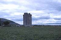
The 16th-century Gleninagh Castle, an L-shaped tower house, stands on a hillside looking out over Galway Bay.[5] The tower measures 31.8 feet (9.7 m) by 27.6 feet (8.4 m). In 1839 it was thatched with straw.[4] There are four stories. The single square turret contains a spiral stairway. The entrance doorway on the first floor of the turret is protected by a machicolation high above. There are round bartizans in three of the main tower's corners. A number of window openings in the end wall were later closed so they could be used for fireplaces.[5]
History
In 1544 King Henry VIII of England granted Gleninagh to Richard Harding. The castle was owned by James Lynch of Galway in 1570. The O'Loughlins, who called themselves "Princes of Burren", owned the castle by 1574. The lands of Gleninagh were owned by the see of Kilfenora in 1629. The O'Loughlins later regained possession of the castle.[6] They still lived there until the 1840s.[5]
In 1837 a parish was in the Catholic union or district of Glyn, or Glenarraha.[7] The population in 1841 was 886 in 146 houses. In 1845 the main settlements were the villages of Glaninagh, Murroghkelly and Murroghwohy.[3] A visitor in 1843 said the castle was being used as a barn by Mr. Blood, its proprietor. The upper part of the building was used as a dove-cot and abounded in pigeons.[8]
Townlands
Townlands are Aghaglinny North, Aghaglinny South, Gleninagh North, Gleninagh South, Murrooghkilly, Murrooghtoohy North and Murrooghtoohy South.[9]
-

Black head
-

View from the saddle in Gleninagh South looking over Galway bay, with Gleninagh Castle near the coast to the left
-

Gleninagh Castle
-

Tobar na Croiche Naoimhe (Well of the Holy Cross)
-

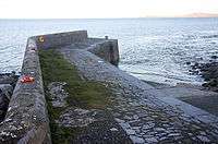
Coolsiva Quay
-

The valley of Gleninagh about Feenagh
References
Citations
Sources
- Breen, Martin (2014). "The History of Gleninagh Castle, Co. Clare". Retrieved 2014-04-08.
- Cooke, Thomas L. (1843). Autumnal Rambles about New Quay, County Clare. Retrieved 2014-04-08.
- Frost, James (1897). "Burren, or Corcomroe East, Gleninagh Parish". The History and Topography of the County of Clare. Retrieved 2014-04-08.
- "Gleann Eidhneach". Placenames Database of Ireland. Retrieved 2014-04-08.
- "Gleninagh Castle". Clare Tourism Forum. Retrieved 2014-04-08.
- Lewis, Samuel (1837). "Glaninagh". County Clare: A History and Topography. Retrieved 2014-04-08.
- "Map of Gleninagh Parish showing Townlands". Clare County Library. Retrieved 2014-04-08.
- O'Donovan, John (1839). "Parish of Gleninagh". Ordnance Survey Letters. Retrieved 2014-04-08.
- "Gleninagh, or Glaninagh". Parliamentary Gazeteer of Ireland 1845. Retrieved 2014-04-08.
| ||||||||||||||||||||||||||||||||||||||||||||||||||||||
