Georgia State Route 91
| ||||
|---|---|---|---|---|
|
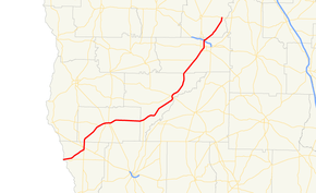
State Route 91 highlighted in red | ||||
| Route information | ||||
| Maintained by GDOT | ||||
| Length: | 85.8 mi[1] (138.1 km) | |||
| Major junctions | ||||
| South end: |
| |||
|
| ||||
| North end: |
| |||
| Location | ||||
| Counties: | Seminole, Miller, Baker, Dougherty, Lee | |||
| Highway system | ||||
| ||||
State Route 91 (SR 91) is a 85.8-mile-long (138.1 km) south–north state highway in the southwest part of the U.S. state of Georgia. The highway travels from its southern terminus at the Florida state line, southwest of Donalsonville, where the roadway continues as State Road 2, northeast through Albany to its northern terminus, an intersection with SR 32 at a point northeast of the city.
Route description
SR 91 begins at the Florida state line, where the roadway continues as State Road 2. Just east of the state line, the route intersects with SR 285. Northeast, in Donalsonville, the route intersects US 84/SR 38/SR 39. The four routes share a very brief concurrency through the city. Just prior to leaving the city, SR 39 departs the concurrency to the south, while SR 91 departs to the north. Southwest of Colquitt, is an intersection with SR 273. Just west of the city, SR 91 intersects SR 45. The two routes begin a concurrency to the northeast. Just after that, the three routes intersect US 27/SR 1. The three-route concurrency heads east to Colquitt. In the city, US 27/SR 1 depart to the southeast, while SR 45/SR 91 continue to the east. Just to the east, SR 45 departs to the north, while SR 91 heads east. SR 91 heads northeast to an intersection with SR 253. The route heads northeast to Newton. In Newton, the route intersects SR 37 and SR 200. Just southwest of Albany, SR 91 intersects SR 62. In the city, is an intersection with SR 234. Farther into the city, is an intersection with US 19 BUS/US 82 BUS/SR 520 BUS. Just before leaving Albany, the route intersects the Liberty Expressway (US 19/US 82/SR 3/SR 133/SR 520). SR 91 heads northeast until it reaches its northern terminus, at an intersection with SR 32. The roadway continues as Philema Road North.[1]
Major intersections
| County | Location | mi[1] | km | Destinations | Notes |
|---|---|---|---|---|---|
| Seminole | 0.0 | 0.0 | Florida state line (Chattahoochee River bridge) | ||
| 1.9 | 3.1 | ||||
| Donalsonville | 8.3 | 13.4 | |||
| 8.6 | 13.8 | Southern end of SR 39 concurrency | |||
| 9.2 | 14.8 | ||||
| 9.4 | 15.1 | Northern end of SR 39 concurrency | |||
| 10.2 | 16.4 | ||||
| Miller | 19.5 | 31.4 | |||
| Colquitt | 21.5 | 34.6 | Southern end of SR 45 concurrency | ||
| 21.7 | 34.9 | Southern end of US 27 / SR 1 concurrency | |||
| 23.1 | 37.2 | Northern end of US 27 / SR 1 concurrency | |||
| 23.3 | 37.5 | traffic circle around Miller County Courthouse; north end of SR 45 overlap; south end of SR 45 Truck overlap | |||
| north end of SR 45 Truck overlap | |||||
| Baker | |||||
| Newton | 50.4 | 81.1 | |||
| 50.6 | 81.4 | ||||
| Dougherty | 66.8 | 107.5 | Southern end of SR 62 concurrency | ||
| Albany | 70.3 | 113.1 | Northern end of SR 62 concurrency | ||
| 70.5 | 113.5 | ||||
| 72.8 | 117.2 | ||||
| 74.9 | 120.5 | Liberty Expressway exit 5; southern end of SR 133 concurrency | |||
| 75.2 | 121.0 | Northern end of SR 133 concurrency | |||
| Lee | Northern terminus | ||||
1.000 mi = 1.609 km; 1.000 km = 0.621 mi
| |||||
Bannered route
| |
|---|---|
| Location: | Donalsonville |
| Length: | 1.9 mi[2] (3.1 km) |
State Route 91 Alternate (SR 91 Alternate) begins at an intersection with the SR 91 mainline, in the southern part of Donalsonville. It heads north to an intersection with US 84/SR 38. It heads north, then turns northeast, until it intersects SR 39. It heads northeast, turns north, and then heads northeast again until it meets its northern terminus, another intersection with the SR 91 mainline.[2]
See also
- Georgia (U.S. state) portal
- U.S. Roads portal
References
- 1 2 3 Google (October 18, 2012). "Route of SR 91" (Map). Google Maps. Google. Retrieved October 18, 2012.
- 1 2 Google (October 18, 2012). "Route of SR 91 Alternate" (Map). Google Maps. Google. Retrieved October 18, 2012.
External links
![]() Media related to Georgia State Route 91 at Wikimedia Commons
Media related to Georgia State Route 91 at Wikimedia Commons

