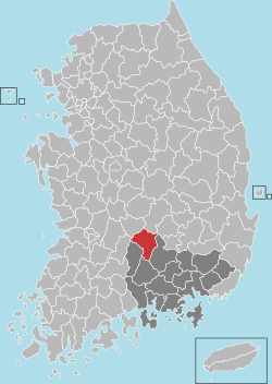
Geochang County
Not to be confused with Gochang County.
"Kochang" redirects here. For a district in Thailand, see Ko Chang.
| Geochang 거창군 | ||
|---|---|---|
| County | ||
| Korean transcription(s) | ||
| • Hangul | 거창군 | |
| • Hanja | 居昌郡 | |
| • Revised Romanization | Geochang-gun | |
| • McCune-Reischauer | Kŏch'ang-gun | |
| ||
 Location in South Korea | ||
| Country |
| |
| Region | Yeongnam | |
| Administrative divisions | 1 eup, 11 myeon | |
| Area | ||
| • Total | 804.09 km2 (310.46 sq mi) | |
| Population (2002) | ||
| • Total | 67,224 | |
| • Density | 83.6/km2 (217/sq mi) | |
| • Dialect | Gyeongsang | |
Geochang County (Geochang-gun, Korean pronunciation: [kʌtɕʰaŋɡun]) is a county in South Gyeongsang Province, South Korea.
Climate
| Climate data for Geochang (1981–2010) | |||||||||||||
|---|---|---|---|---|---|---|---|---|---|---|---|---|---|
| Month | Jan | Feb | Mar | Apr | May | Jun | Jul | Aug | Sep | Oct | Nov | Dec | Year |
| Average high °C (°F) | 5.0 (41) |
7.5 (45.5) |
12.7 (54.9) |
19.6 (67.3) |
24.2 (75.6) |
27.2 (81) |
29.3 (84.7) |
29.8 (85.6) |
25.8 (78.4) |
21.0 (69.8) |
14.0 (57.2) |
7.7 (45.9) |
18.7 (65.7) |
| Daily mean °C (°F) | −1.7 (28.9) |
0.5 (32.9) |
5.4 (41.7) |
11.8 (53.2) |
16.7 (62.1) |
20.9 (69.6) |
24.0 (75.2) |
24.2 (75.6) |
19.2 (66.6) |
12.5 (54.5) |
6.1 (43) |
0.4 (32.7) |
11.7 (53.1) |
| Average low °C (°F) | −7.5 (18.5) |
−5.6 (21.9) |
−1.1 (30) |
4.3 (39.7) |
9.6 (49.3) |
15.3 (59.5) |
20.0 (68) |
20.2 (68.4) |
14.2 (57.6) |
6.1 (43) |
−0.3 (31.5) |
−5.6 (21.9) |
5.8 (42.4) |
| Average precipitation mm (inches) | 27.9 (1.098) |
37.5 (1.476) |
55.1 (2.169) |
75.4 (2.969) |
94.9 (3.736) |
174.2 (6.858) |
301.4 (11.866) |
284.8 (11.213) |
166.0 (6.535) |
44.3 (1.744) |
35.9 (1.413) |
19.2 (0.756) |
1,316.8 (51.843) |
| Average precipitation days (≥ 0.1 mm) | 5.5 | 5.7 | 7.3 | 8.0 | 8.4 | 9.7 | 14.6 | 13.5 | 8.3 | 5.2 | 6.2 | 4.9 | 97.3 |
| Average relative humidity (%) | 64.7 | 63.0 | 61.9 | 60.7 | 66.2 | 72.0 | 79.3 | 79.4 | 77.6 | 72.8 | 69.3 | 67.0 | 69.5 |
| Mean monthly sunshine hours | 193.1 | 191.9 | 216.3 | 233.1 | 244.2 | 203.3 | 176.6 | 183.0 | 172.0 | 200.7 | 174.6 | 182.4 | 2,373.7 |
| Source: Korea Meteorological Administration[1] | |||||||||||||
Twin towns – Sister cities
Geochang is twinned with:
-
 Gokseong, South Korea (1998)
 -
 Gangdong-gu, South Korea (1999)
 -
 Gaoyou, China (2005)
 -
 Yeongdo-gu, South Korea (2006)
 -
 Suseong-gu, South Korea (2006)
 -
 Seocho-gu, South Korea (2007)
See also
References
- ↑ "평년값자료(1981–2010) 거창(284)". Korea Meteorological Administration. Retrieved 2011-05-07.
External links
| Wikimedia Commons has media related to Geochang, Gyeongsangnam-do. |
| |||||||||||||||||||||||||||
Coordinates: 35°41′N 127°54′E / 35.683°N 127.900°E
This article is issued from Wikipedia - version of the Thursday, November 27, 2014. The text is available under the Creative Commons Attribution/Share Alike but additional terms may apply for the media files.

