Garrabost
| Garrabost | |
| Scottish Gaelic: Garrabost | |
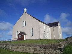
 Knock Free Church (situated in Garrabost) |
|
 Garrabost |
|
| Language | Scottish Gaelic |
|---|---|
| English | |
| OS grid reference | NB523330 |
| Civil parish | Stornoway |
| Council area | Na h-Eileanan Siar |
| Lieutenancy area | Western Isles |
| Country | Scotland |
| Sovereign state | United Kingdom |
| Post town | ISLE OF LEWIS |
| Postcode district | HS2 |
| Dialling code | 01851 |
| Police | Scottish |
| Fire | Scottish |
| Ambulance | Scottish |
| EU Parliament | Scotland |
| UK Parliament | Na h-Eileanan an Iar |
| Scottish Parliament | Na h-Eileanan an Iar |
Coordinates: 58°13′01″N 6°13′01″W / 58.217°N 6.217°W
Garrabost (Scottish Gaelic: Garrabost) is a village in the Point (An Rubha) peninsula isthmus on the east coast of the Isle of Lewis, in the Outer Hebrides, Scotland. The village is one of the largest in Point, comprising Upper and Lower Garrabost, and Claypark. Garrabost is within the civil parish of Stornoway.[1] The church parish for Point is called Knock, and both Knock Church of Scotland and Knock Free Church of Scotland are located in Garrabost. Garrabost is situated on the A866, between Stornoway and Portnaguran.[2]
References
- ↑ "Details of Garrabost". Scottish Places. Retrieved 23 December 2014.
- ↑ "A866". Sabre. Retrieved 23 December 2014.
External links
| Wikimedia Commons has media related to Garrabost. |
- Canmore - Lewis, Garrabost, Mill site record
- Canmore - Lewis, Garrabost Brickworks site record
- Canmore - Lewis, Garrabost, Parish Church site record
- Canmore - Lewis, Garrabost, Free Church site record
- Canmore - Lewis, Garrabost, Cnoc An Oil site record
- Canmore - Lewis, Garrabost, Dursainean Standing Stone site record
- Canmore - Lewis, Garrabost, St Cowstan's Chapel site record
- Canmore - Lewis, Garrabost, Cnoc Nan Dursainean site record
| |||||||||||||||||||||||||||||||||
This article is issued from Wikipedia - version of the Sunday, January 24, 2016. The text is available under the Creative Commons Attribution/Share Alike but additional terms may apply for the media files.