Garland, Kansas
| Garland, Kansas | |
|---|---|
| Unincorporated community | |
 Garland, Kansas | |
| Coordinates: 37°43′54″N 94°37′21″W / 37.73167°N 94.62250°WCoordinates: 37°43′54″N 94°37′21″W / 37.73167°N 94.62250°W | |
| Country | United States |
| State | Kansas |
| County | Bourbon |
| Elevation | 853 ft (260 m) |
| Time zone | Central (CST) (UTC-6) |
| • Summer (DST) | CDT (UTC-5) |
| ZIP code | 66741 |
| Area code(s) | 620 |
| GNIS feature ID | 475024[1] |
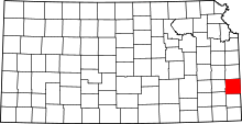
Garland is an unincorporated community in Bourbon County, Kansas, United States. Garland is located along the Missouri state line 8.5 miles (13.7 km) southwest of Fort Scott.
History
Garland was originally called Memphis. The name was changed to Garland (after a brand of stoves) when the railroad came through in the 1880s.[2]
Further reading
References
- ↑ "US Board on Geographic Names". United States Geological Survey. 2007-10-25. Retrieved 2008-01-31.
- ↑ "Many Towns Have Disappeared". The Fort Scott Tribune. Jul 16, 1976. pp. 2C. Retrieved 16 May 2015.
| |||||||||||||||||||||
This article is issued from Wikipedia - version of the Saturday, May 16, 2015. The text is available under the Creative Commons Attribution/Share Alike but additional terms may apply for the media files.
