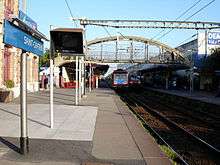
Gare de Saint-Gratien
 | |||||||||||
| Coordinates | 48°57′50″N 2°17′07″E / 48.963826°N 2.28514°ECoordinates: 48°57′50″N 2°17′07″E / 48.963826°N 2.28514°E | ||||||||||
| Owned by | SNCF | ||||||||||
| Line(s) | RER C | ||||||||||
| Platforms | 2 outside | ||||||||||
| Tracks | 2 | ||||||||||
| Other information | |||||||||||
| Fare zone | IDF/4 (Orange Card) | ||||||||||
| History | |||||||||||
| Opened | 25 September 1988 | ||||||||||
| Traffic | |||||||||||
| Passengers | 2,500–7,500 (2004)[1] | ||||||||||
| Services | |||||||||||
| |||||||||||
The Gare de Saint-Gratien (Saint-Gratien station) is a railway station in the commune of Saint-Gratien, Val-d’Oise department, France.
The station
The station was built by the Nord company in 1906 and opened in 1908 when the extension to St. Gratien and Ermont was placed in service.[2]
The station is served by trains on Branch C1 of the RER C.
In 2004, the number of passengers per day was between 2,500 and 7,500.[1]

Platforms
References
- 1 2 STIF - Atlas des transports publics en Île-de-France (Atlas of Public Transport in the Île-de-France) (French)
- ↑ "Histoire: La gare de Saint Gratien (1ère partie)", Saint Gratien Magazine 87 Nov. 2006 (French) (pdf)
| Wikimedia Commons has media related to Gare de Saint-Gratien. |
This article is issued from Wikipedia - version of the Wednesday, May 06, 2015. The text is available under the Creative Commons Attribution/Share Alike but additional terms may apply for the media files.