River Garavogue
| River Garavogue An Gharbhóg | |
|---|---|
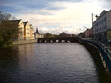
 River Garavogue in the centre of Sligo Town | |
| Main source | Lough Gill |
| River mouth | Atlantic Ocean at Sligo Bay |
The Garavogue (Irish: An Gharbhóg[1]) is a river located in County Sligo, Ireland. From Lough Gill, it winds its way through Sligo town and into Sligo Bay. The river has a large estuary with a shipping channel capable of taking ships up to 10,000 tons, but now fallen into disuse and used mainly by smaller pleasure craft. The River Garavogue (including L. Gill and R. Bonnet) is 31.5 miles (50.7 km)[2] long.
Etymology
The name, Garavogue, is uncertain, but may be a representation of "garbh óg" meaning "young rough". However this is not the original name of the river. The river was originally called the Sligeach, a name meaning abounding in shells and is one of the oldest attested placenames in Ireland. The river gave its name firstly to the town that grew up on its banks from the 13th century, and then to the county that was established in the late 16th and early 17th century.
History
It is mentioned in Early Medieval texts as one of the "nine royal rivers" of Ireland.
Saint Patrick is said to have blessed it so that it would produce salmon all year round.
A farset or fording point (literally a sandbar) named Reanna na Líagáin was located across this estuary that formed part of the main north/south route from western Ulster to Connacht. The terminals of the crossing were between Ballincar and Finisklin.
The battle of Sligo (river) took place at this river in 536 AD between Eoghan Bél king of Connacht and the Uí Néill.
References
- ↑ logainm.ie, accessed 21 May 2009
- ↑ Ordnance Survey of Ireland: Rivers and their Catchment Basins 1958 (Table of Reference)
Coordinates: 54°16′26″N 8°28′30″W / 54.274°N 8.475°W