Francis Beidler Forest
| Francis Beidler Forest | |
|---|---|
|
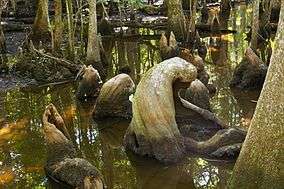
Cypress knees from the Beidler Forest. | |
 Map of South Carolina | |
| Location | South-central South Carolina |
| Coordinates | 33°14′02″N 80°21′40″W / 33.23389°N 80.36111°WCoordinates: 33°14′02″N 80°21′40″W / 33.23389°N 80.36111°W |
| Area | 16,000 acres (6,500 ha) |
| Governing body | National Audubon Society |
| http://beidlerforest.audubon.org/ | |
| Designated | May 30, 2008 |
| Designated | 1979 |
The Francis Beidler Forest is an Audubon wildlife sanctuary in Four Holes Swamp, a blackwater creek system in South Carolina. It consists of over 16,000 acres (65 km²) of mainly bald cypress and tupelo gum hardwood forest and swamp with approximately 1,800 acres (7 km2) of old-growth forest. It is the largest virgin stand of these trees in the world, with some trees over 1,000 years old. It is a favorite haunt of birdwatchers and is used for biological research projects by area schools.
The preserve was established to protect 1,800 acres of what was then one of only two stands of old-growth forest in South Carolina. On May 30, 2008 the forest was designated a Ramsar Wetland of International Importance. It was designated a National Natural Landmark in 1979.[1]
History
The land was acquired by Francis Beidler in the 1890s, and maintained by his family after his death in 1924. On liquidation of the estate, the National Audubon Society raised the funds to acquire the land, build a boardwalk, and purchase land from surrounding farmers to ensure access. In 2003 the Audubon Society which maintains the preserve announced it had recently obtained funding with which to purchase an additional 909 acres of adjacent land to expand the preserve.[2]
Facilities
It has an environmental education center and a 1.75-mile (2.82 km) boardwalk trail through the old-growth portion of the swamp, established in 1977. A free iPhone/iPod Touch app can be downloaded from the iTunes Store to provide information and images not available in the printed guidebook as well as species lists for plants and animals likely to be seen from the boardwalk. At high water there is guided canoeing in the swamp, which offers a different perspective as one paddles through the shallow channel and cypress knees.
Location
336 Sanctuary Road, Harleyville, South Carolina 29448
See also
References
Sources
- National Recreation Trails: Francis Beidler Forest
- Southern Forests: Francis Beidler Forest
- Text of The Francis Beidler Forest in Four Holes Swamp
- Francis Beidler - text from guidebook
