First Coast Commuter Rail
| First Coast Commuter Rail | |||||||||||||||||||||||||||||||||||||||||||||||||||||||||||||||||||||||||||||||||||||||||||||||||||||||||||||||||||||||||||||||||||||||||||||||||||||||||||||||||||||||||||||||||||||||||||||||||||||||||||||||||||||||||||||||||||||||||||||||||||||||||||||||||||||||||||||||||||||||||||||||||||||||||||||||||||||||||||||||||||||||||||||||||||||||||||||||||||||||||||||||||||||||||||||||||||||||||||||||||||||||||||||||||||||||||||||||||||||||||||||||||||||||||||||||||||||||||||||||||||||||||||||||||||||||||||||||||||||||||||||||||||||||||||||||||
|---|---|---|---|---|---|---|---|---|---|---|---|---|---|---|---|---|---|---|---|---|---|---|---|---|---|---|---|---|---|---|---|---|---|---|---|---|---|---|---|---|---|---|---|---|---|---|---|---|---|---|---|---|---|---|---|---|---|---|---|---|---|---|---|---|---|---|---|---|---|---|---|---|---|---|---|---|---|---|---|---|---|---|---|---|---|---|---|---|---|---|---|---|---|---|---|---|---|---|---|---|---|---|---|---|---|---|---|---|---|---|---|---|---|---|---|---|---|---|---|---|---|---|---|---|---|---|---|---|---|---|---|---|---|---|---|---|---|---|---|---|---|---|---|---|---|---|---|---|---|---|---|---|---|---|---|---|---|---|---|---|---|---|---|---|---|---|---|---|---|---|---|---|---|---|---|---|---|---|---|---|---|---|---|---|---|---|---|---|---|---|---|---|---|---|---|---|---|---|---|---|---|---|---|---|---|---|---|---|---|---|---|---|---|---|---|---|---|---|---|---|---|---|---|---|---|---|---|---|---|---|---|---|---|---|---|---|---|---|---|---|---|---|---|---|---|---|---|---|---|---|---|---|---|---|---|---|---|---|---|---|---|---|---|---|---|---|---|---|---|---|---|---|---|---|---|---|---|---|---|---|---|---|---|---|---|---|---|---|---|---|---|---|---|---|---|---|---|---|---|---|---|---|---|---|---|---|---|---|---|---|---|---|---|---|---|---|---|---|---|---|---|---|---|---|---|---|---|---|---|---|---|---|---|---|---|---|---|---|---|---|---|---|---|---|---|---|---|---|---|---|---|---|---|---|---|---|---|---|---|---|---|---|---|---|---|---|---|---|---|---|---|---|---|---|---|---|---|---|---|---|---|---|---|---|---|---|---|---|---|---|---|---|---|---|---|---|---|---|---|---|---|---|---|---|---|---|---|---|---|---|---|---|---|---|---|---|---|---|---|---|---|---|---|---|---|---|---|---|---|---|---|---|---|---|---|---|---|---|---|---|---|---|---|---|---|---|---|---|---|---|---|---|---|---|---|---|---|---|---|---|---|---|---|---|---|---|---|---|---|---|---|---|---|---|---|---|---|---|---|---|---|---|---|---|---|---|---|---|---|---|---|---|---|---|---|---|---|---|---|---|---|---|---|---|---|---|---|---|---|---|---|---|---|---|---|---|---|---|---|---|---|---|---|---|---|---|---|---|---|---|---|---|---|---|---|---|---|---|---|---|---|---|---|---|---|
| Overview | |||||||||||||||||||||||||||||||||||||||||||||||||||||||||||||||||||||||||||||||||||||||||||||||||||||||||||||||||||||||||||||||||||||||||||||||||||||||||||||||||||||||||||||||||||||||||||||||||||||||||||||||||||||||||||||||||||||||||||||||||||||||||||||||||||||||||||||||||||||||||||||||||||||||||||||||||||||||||||||||||||||||||||||||||||||||||||||||||||||||||||||||||||||||||||||||||||||||||||||||||||||||||||||||||||||||||||||||||||||||||||||||||||||||||||||||||||||||||||||||||||||||||||||||||||||||||||||||||||||||||||||||||||||||||||||||||
| Type | Commuter rail | ||||||||||||||||||||||||||||||||||||||||||||||||||||||||||||||||||||||||||||||||||||||||||||||||||||||||||||||||||||||||||||||||||||||||||||||||||||||||||||||||||||||||||||||||||||||||||||||||||||||||||||||||||||||||||||||||||||||||||||||||||||||||||||||||||||||||||||||||||||||||||||||||||||||||||||||||||||||||||||||||||||||||||||||||||||||||||||||||||||||||||||||||||||||||||||||||||||||||||||||||||||||||||||||||||||||||||||||||||||||||||||||||||||||||||||||||||||||||||||||||||||||||||||||||||||||||||||||||||||||||||||||||||||||||||||||||
| Status | Alternative Study Stage | ||||||||||||||||||||||||||||||||||||||||||||||||||||||||||||||||||||||||||||||||||||||||||||||||||||||||||||||||||||||||||||||||||||||||||||||||||||||||||||||||||||||||||||||||||||||||||||||||||||||||||||||||||||||||||||||||||||||||||||||||||||||||||||||||||||||||||||||||||||||||||||||||||||||||||||||||||||||||||||||||||||||||||||||||||||||||||||||||||||||||||||||||||||||||||||||||||||||||||||||||||||||||||||||||||||||||||||||||||||||||||||||||||||||||||||||||||||||||||||||||||||||||||||||||||||||||||||||||||||||||||||||||||||||||||||||||
| Locale | North Florida | ||||||||||||||||||||||||||||||||||||||||||||||||||||||||||||||||||||||||||||||||||||||||||||||||||||||||||||||||||||||||||||||||||||||||||||||||||||||||||||||||||||||||||||||||||||||||||||||||||||||||||||||||||||||||||||||||||||||||||||||||||||||||||||||||||||||||||||||||||||||||||||||||||||||||||||||||||||||||||||||||||||||||||||||||||||||||||||||||||||||||||||||||||||||||||||||||||||||||||||||||||||||||||||||||||||||||||||||||||||||||||||||||||||||||||||||||||||||||||||||||||||||||||||||||||||||||||||||||||||||||||||||||||||||||||||||||
| Termini |
Central: Downtown Jacksonville, FL North: Yulee, FL Southwest: Green Cove Springs, FL Southeast: St Augustine, FL | ||||||||||||||||||||||||||||||||||||||||||||||||||||||||||||||||||||||||||||||||||||||||||||||||||||||||||||||||||||||||||||||||||||||||||||||||||||||||||||||||||||||||||||||||||||||||||||||||||||||||||||||||||||||||||||||||||||||||||||||||||||||||||||||||||||||||||||||||||||||||||||||||||||||||||||||||||||||||||||||||||||||||||||||||||||||||||||||||||||||||||||||||||||||||||||||||||||||||||||||||||||||||||||||||||||||||||||||||||||||||||||||||||||||||||||||||||||||||||||||||||||||||||||||||||||||||||||||||||||||||||||||||||||||||||||||||
| Website | http://www.jtafla.com/JTAfutureplans/Rail/ | ||||||||||||||||||||||||||||||||||||||||||||||||||||||||||||||||||||||||||||||||||||||||||||||||||||||||||||||||||||||||||||||||||||||||||||||||||||||||||||||||||||||||||||||||||||||||||||||||||||||||||||||||||||||||||||||||||||||||||||||||||||||||||||||||||||||||||||||||||||||||||||||||||||||||||||||||||||||||||||||||||||||||||||||||||||||||||||||||||||||||||||||||||||||||||||||||||||||||||||||||||||||||||||||||||||||||||||||||||||||||||||||||||||||||||||||||||||||||||||||||||||||||||||||||||||||||||||||||||||||||||||||||||||||||||||||||
| Operation | |||||||||||||||||||||||||||||||||||||||||||||||||||||||||||||||||||||||||||||||||||||||||||||||||||||||||||||||||||||||||||||||||||||||||||||||||||||||||||||||||||||||||||||||||||||||||||||||||||||||||||||||||||||||||||||||||||||||||||||||||||||||||||||||||||||||||||||||||||||||||||||||||||||||||||||||||||||||||||||||||||||||||||||||||||||||||||||||||||||||||||||||||||||||||||||||||||||||||||||||||||||||||||||||||||||||||||||||||||||||||||||||||||||||||||||||||||||||||||||||||||||||||||||||||||||||||||||||||||||||||||||||||||||||||||||||||
| Character | At-grade | ||||||||||||||||||||||||||||||||||||||||||||||||||||||||||||||||||||||||||||||||||||||||||||||||||||||||||||||||||||||||||||||||||||||||||||||||||||||||||||||||||||||||||||||||||||||||||||||||||||||||||||||||||||||||||||||||||||||||||||||||||||||||||||||||||||||||||||||||||||||||||||||||||||||||||||||||||||||||||||||||||||||||||||||||||||||||||||||||||||||||||||||||||||||||||||||||||||||||||||||||||||||||||||||||||||||||||||||||||||||||||||||||||||||||||||||||||||||||||||||||||||||||||||||||||||||||||||||||||||||||||||||||||||||||||||||||
| Technical | |||||||||||||||||||||||||||||||||||||||||||||||||||||||||||||||||||||||||||||||||||||||||||||||||||||||||||||||||||||||||||||||||||||||||||||||||||||||||||||||||||||||||||||||||||||||||||||||||||||||||||||||||||||||||||||||||||||||||||||||||||||||||||||||||||||||||||||||||||||||||||||||||||||||||||||||||||||||||||||||||||||||||||||||||||||||||||||||||||||||||||||||||||||||||||||||||||||||||||||||||||||||||||||||||||||||||||||||||||||||||||||||||||||||||||||||||||||||||||||||||||||||||||||||||||||||||||||||||||||||||||||||||||||||||||||||||
| Line length | 91 mi (146 km)[1] | ||||||||||||||||||||||||||||||||||||||||||||||||||||||||||||||||||||||||||||||||||||||||||||||||||||||||||||||||||||||||||||||||||||||||||||||||||||||||||||||||||||||||||||||||||||||||||||||||||||||||||||||||||||||||||||||||||||||||||||||||||||||||||||||||||||||||||||||||||||||||||||||||||||||||||||||||||||||||||||||||||||||||||||||||||||||||||||||||||||||||||||||||||||||||||||||||||||||||||||||||||||||||||||||||||||||||||||||||||||||||||||||||||||||||||||||||||||||||||||||||||||||||||||||||||||||||||||||||||||||||||||||||||||||||||||||||
| Track gauge | 1,435 mm (4 ft 8 1⁄2 in) | ||||||||||||||||||||||||||||||||||||||||||||||||||||||||||||||||||||||||||||||||||||||||||||||||||||||||||||||||||||||||||||||||||||||||||||||||||||||||||||||||||||||||||||||||||||||||||||||||||||||||||||||||||||||||||||||||||||||||||||||||||||||||||||||||||||||||||||||||||||||||||||||||||||||||||||||||||||||||||||||||||||||||||||||||||||||||||||||||||||||||||||||||||||||||||||||||||||||||||||||||||||||||||||||||||||||||||||||||||||||||||||||||||||||||||||||||||||||||||||||||||||||||||||||||||||||||||||||||||||||||||||||||||||||||||||||||
| |||||||||||||||||||||||||||||||||||||||||||||||||||||||||||||||||||||||||||||||||||||||||||||||||||||||||||||||||||||||||||||||||||||||||||||||||||||||||||||||||||||||||||||||||||||||||||||||||||||||||||||||||||||||||||||||||||||||||||||||||||||||||||||||||||||||||||||||||||||||||||||||||||||||||||||||||||||||||||||||||||||||||||||||||||||||||||||||||||||||||||||||||||||||||||||||||||||||||||||||||||||||||||||||||||||||||||||||||||||||||||||||||||||||||||||||||||||||||||||||||||||||||||||||||||||||||||||||||||||||||||||||||||||||||||||||||
The First Coast Commuter Rail is a proposed commuter rail system serving Jacksonville, FL and northeast Florida. It is currently in the very early planning stages, having completed the first step of a feasibility study and currently pursuing an alternatives analysis.
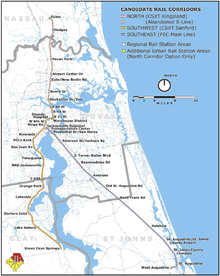
Three routes were analyzed indepth, north to Yulee, FL, southwest to Green Cove Springs, FL and the southeast to St. Augustine, FL.[3]
A feasibility study was completed in November 2009 for the Jacksonville Transportation Authority (JTA). James Boyle, JTA's regional transportation planner, has since said that there are no fatal flaws in the study.[4]
History
JTA hired a consultant to conduct a feasibility study in early 2008 at the cost of $400,000. It was completed in November 2009[5] The study looked into 7 routes, most along existing freight rail right of ways. Three of these, north to Yulee, FL, southwest to Green Cove Springs, FL and the southeast to St. Augustine, FL were selected for in depth study.[6] In the Summer of 2010, JTA allocated $1 Million for an Alternative Analysis study on the proposed system. This is required step to participate in the Federal Transit Administration's (FTA) New Starts program.[7]
In May 2013, St. Augustine City Commission voted in a resolution supporting the proposal of a commuter train service on the southeast corridor. JTA says that the federal government could fund half of southeast corridor project, estimated to cost about $193.3 million. The proposal still needs approval from St. Johns County, The North Florida Transportation Planning Organization board and the Jacksonville Transportation Authority board.[8]
Routes

All routes in the in-depth study start in downtown Jacksonville and head out in one of three directions, North, Southwest and Southeast.
North Corridor
| North Corridor | |
|---|---|
| Overview | |
| System | First Coast Commuter Rail |
| Status | Planning (Alternatives Analysis) |
| Termini |
Downtown Jacksonville, FL Yulee, FL |
| Stations | 15 |
| Daily ridership | 1020 to 2040 (Projected 2015) |
| Technical | |
| Line length | 23.7 mi (38.1 km) |
The North Corridor originates in Downtown Jacksonville, and heads North along the abandon S-Line to the CSX Kingsland division line to Yulee, FL. The Kingsland division line is a remnant of the Seaboard Coast Line’s mainline. The route passes two miles (3 km) from Jacksonville International Airport.
Southwest Corridor
| Southwest Corridor | |
|---|---|
| Overview | |
| System | First Coast Commuter Rail |
| Status | Planning (Alternatives Analysis) |
| Termini |
Downtown Jacksonville, FL Green Cove Springs, FL |
| Stations | 12 |
| Daily ridership | 1490 to 2970 (Projected 2015) |
| Technical | |
| Line length | 29.3 mi (47.2 km) |
The Southwest Corridor originates in Downtown Jacksonville, and heads South along the CSX A-Line to Green Cove Springs, FL.
Southeast Corridor
| Southeast Corridor | |
|---|---|
| Overview | |
| System | First Coast Commuter Rail |
| Status | Planning (Alternatives Analysis) |
| Termini |
Downtown Jacksonville, FL St. Augustine, FL |
| Stations | 13 |
| Daily ridership | 2410 to 4810 (Projected 2015) |
| Technical | |
| Line length | 38.4 mi (61.8 km) |
The Southeast Corridor originates in Downtown Jacksonville, and heads Southeast along the Florida East Coast Railway's main line to St. Augustine, FL. The proposed 38.4-mile (61.8 km) route is the northernmost part of a 368-mile (592 km) freight rail line to Miami.
The corridor already serves 17 regularly scheduled interregional freight trains a day. The 2009 feasibility study estimated that this route could carry an estimated 5,132 riders in 2015 and 5,469 by 2020 on trains between Jacksonville and St. Augustine. Travel time is estimated at 51 minutes end to end. [9]
Notable proposed stops along the route include Palencia, The Northeast Florida Regional Airport, the St. Johns County Complex, downtown St. Augustine, West Augustine, Race Track Road, Avenues and JTB.[10][11]
See also
Northeast Florida Regional Transportation Commission
References
- ↑ JTA finds ‘no fatal flaws’ in commuter rail study
- ↑ title=Candidate Rail Stations |accessdate=2011-02-04 |publisher=Jacksonville Transportation Authority}}
- ↑ Feasibility Study Final Report
- ↑ JTA finds ‘no fatal flaws’ in commuter rail study
- ↑ http://jacksonville.com/news/metro/2009-09-28/story/report_jacksonville_commuter_rail_would_be_costly
- ↑ Feasibility Study Final Report
- ↑ http://www.metrojacksonville.com/article/2010-jul-jacksonville-commuter-rail-plans-progressing
- ↑ http://www.actionnewsjax.com/content/topstories/story/Commuter-rail-from-Saint-Augustine-to-Jax-gets/FXGBaYRtu0K5Ui5YjObp2Q.cspx
- ↑ http://m.staugustine.com/news/local-news/2013-05-12/st-augustine-asked-support-commuter-rail-link-jax
- ↑ http://www.actionnewsjax.com/content/topstories/story/Commuter-rail-from-Saint-Augustine-to-Jax-gets/FXGBaYRtu0K5Ui5YjObp2Q.cspx
- ↑ http://m.staugustine.com/news/local-news/2013-05-12/st-augustine-asked-support-commuter-rail-link-jax