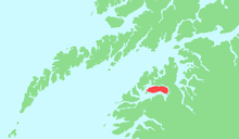
Finnøya, Nordland
 Northwestern coast of Finnøya, with the Hamarøy coastal mountains behind | |
 Location in Nordland | |
| Geography | |
|---|---|
| Location | Nordland, Norway |
| Coordinates | 68°00′08″N 15°29′49″E / 68.0022°N 15.4969°ECoordinates: 68°00′08″N 15°29′49″E / 68.0022°N 15.4969°E |
| Area | 68 km2 (26 sq mi) |
| Highest elevation | 436 m (1,430 ft) |
| Highest point | Straumfjellet |
| Norway | |
| County | Nordland |
| Municipality | Hamarøy |
| Demographics | |
| Population | 52 (as of 2001) |
Finnøya is an island in the municipality of Hamarøy in Nordland county, Norway. The island is situated northwest of the village of Innhavet with which it is connected by bridge. The mountainous island has an area of 68 square kilometres (26 sq mi) and the highest point is the 436-metre (1,430 ft) tall mountain Straumfjellet. In 2001, the island of Finnøya had a population of 52.[1]
Sagfjord Church is located on the south side of the island in the village of Karlsøy.
References
- ↑ Store norske leksikon. "Finnøy – øy i Hamarøy" (in Norwegian). Retrieved 2012-05-02.
This article is issued from Wikipedia - version of the Friday, March 01, 2013. The text is available under the Creative Commons Attribution/Share Alike but additional terms may apply for the media files.