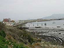
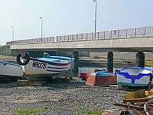
Ferry Bridge, Dorset

Ferry Bridge is at the beginning of the causeway to the Isle of Portland, Dorset, England, and is the point at which the Fleet lagoon joins Portland Harbour. It is situated several hundred metres south of the Portland's boundary with the village of Wyke Regis, Weymouth. To the west of Ferry Bridge is the start of The Fleet, which is an internationally important nature reserve that extends to Abbotsbury Swannery, whilst to the east of the area is Portland Harbour. Along the harbour side is Smallmouth Beach.
The last building on the mainland before entering Portland is the Ferry Bridge pub, which was once known as the Royal Victoria Inn. The first building on Portland is the Chesil Beach Centre; a nature study centre.[1] Ferry Bridge is also a popular dive site.[2]
History


The only road between Portland and the Mainland (the A354) passes across Ferry Bridge. Before 1839 there was no road connection between the Royal Manor of Portland and mainland England. The crossing was treacherous and people and animals were carried in a small boat using ropes spanning across the gap.[3]
During November 1824 a storm breached Chesil Beach, and caused destruction at the Smallmouth Passage. It became known as "The Great Gale of 1824", and the Ferry House was destroyed.[4] The storm left the passage more unsafe and dangerous than it ever had been before.[5] There had been unsuccessful petitions during the late 18th-century for a bridge to be built at Smallmouth, and the storm of 1824 added weight to this demand. The first bridge over the passage was built in 1839.[6] This original bridge charged tolls, as it was maintained by a body of Bridge Commissioners. The bridge helped make the surrounding area a popular attraction for locals and visitors.[7]
During 1894 the Bridge Commissioners began to negotiate with Dorset's County Council over the transfer of the bridge to the council. The bridge had fallen into a poor state, and the council were interested in rebuilding and maintaining a new structure. The bridge was soon transferred to the Portland Urban District Council, and the second bridge constructed between 1894–96. The bridge was completed and opened fully on 2 March 1896.[8] By the late 20th-century the iron bridge had become rusted and worn-out, which led to the construction of a new concrete bridge, made of Portland stone, which was completed in 1985.[3] As the passage had been realigned during the 1970s, the new bridge was situated several hundred metres south of the original bridge's position.[9]
In 1865, the mainland railway line had been extended from Weymouth to Portland, with the line running between the main road to Portland, and the harbour. In order to get across the Smallmouth passage, a wooden viaduct was built by 1864.[10] In 1902 a new viaduct was built of steel at Ferry Bridge.[11] The railway closed to passengers in 1952, and goods traffic in 1965. The viaduct at Ferry Bridge was demolished in December 1971.[11]
Robert Whitehead's Torpedo Works, a factory built in 1891 to manufacture torpedoes, was once situated on the Wyke Regis side of Ferry Bridge, in the northern part of Portland Harbour. Torpedo testing and practice firing would occur from the northern-most breakwater in the harbour. Before the outbreak of World War 2 there were 1500 workers on the site. The factory was closed and demolished in 1997. The factory site is now a housing estate, named Whitehead Drive, and there is a memorial stone and plaque to commemorate the factory.[12] At Ferry Bridge, close to the bridge itself is a World War II type 22 pillbox. This is one of a number of anti-invasion structures placed along the east of the Fleet. The pillbox was constructed in 1940-41. The pillbox has an external blast wall, which is now separate from the pillbox, possibly due to subsidence.[13]
References
- ↑ "Ferrybridge, Portland, Dorset". Geoffkirby.co.uk. Retrieved 10 June 2013.
- ↑ "ferrybridge". Underwater Explorers. Retrieved 10 June 2013.
- 1 2 http://www.geoffkirby.co.uk/Portland/660750/
- ↑ http://www.dorsetlife.co.uk/2013/01/the-great-gale-of-1824/
- ↑ http://freepages.genealogy.rootsweb.ancestry.com/~pbtyc/Portland/PYB/Catastophes.html
- ↑ Mackenzie, Roy (1999). Portland: A Topographical and Historical Gazetteer. p. 21.
- ↑ http://www.southampton.ac.uk/~imw/Portland-Harbour.htm
- ↑ http://freepages.genealogy.rootsweb.ancestry.com/~pbtyc/Portland/PYB/Ferry_Bridge.html
- ↑ "Pictures - Ferrybridge". Chesilbeach.org. Retrieved 10 June 2013.
- ↑ http://www.disused-stations.org.uk/p/portland_first/
- 1 2 http://www.sandsfootcastle.org.uk/the-rodwell-trail/
- ↑ http://www.weymouthinoldpostcards.co.uk/whitehead%20torpedo%20woirks.htm
- ↑ Historic England. "Monument No. 1419087". PastScape. Retrieved 6 October 2015.
| ||||||||||||||||||||||||||||||||||||||||||||||||||||||||||||||||||
Coordinates: 50°34′59″N 2°28′16″W / 50.5830°N 2.4712°W