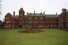
Fair Mile Hospital
| Fair Mile Hospital | |
|---|---|
| Formerly NHS | |
 Front facade. | |
| Geography | |
| Location | Cholsey, Oxfordshire, England, United Kingdom |
| Organisation | |
| Care system | Public NHS |
| Hospital type | Psychiatric |
| Services | |
| Beds | over 1,000 |
| History | |
| Founded | 1870 |
| Closed | 2003 |
| Links | |
| Lists | Hospitals in England |

Fair Mile Hospital (aka Fairmile Hospital) was a lunatic asylum north of Moulsford[1] and east of Cholsey,[2] near the River Thames between Wallingford and Reading in England, formerly in Berkshire and from 1974 with the boundary changes in Oxfordshire.
The UK 1845 County Asylums Act required all counties to provide residential treatment for those with mentall illness.[1] The hospital was opened in 1870 as the County Lunatic Asylum for Berkshire.[3] Previous names include the Moulsford Asylum (1867–97), Berkshire Lunatic Asylum (1897–c.1915), and Berkshire Mental Hospital (c.1915–48).[4][1] The architect George Thomas Hine designed extensions for the building in 1898. The hospital became part of the National Health Service in 1948 under its final name, Fair Mile Hospital.[5] At its peak, the hospital held over a thousand patients.[6] The facility closed in 2003 when use had declined due to modern mental health policy and treatment.[3] The Victorian buildings remain substantially complete, having been converted to dwellings. New housing occupies other parts of the site, largely confined to areas previously used for ancillary structures.
References
- 1 2 3 "Fair Mile Hospital". UK: Berkshire Family History Society. Retrieved 22 August 2015.
- ↑ Sloan, Liam (22 September 2010). "Pictures shed light on history of Cholsey psychiatric hospital". Oxford Mail.
- 1 2 "A History of Fair Mile Hospital 1870–2003". UK: Berkshire Record Office. Retrieved 22 August 2015.
- ↑ "Fair Mile Hospital". UK: The National Archives. Retrieved 22 August 2015.
- ↑ "Fair Mile Hospital". Oxfordshire Health Archives. UK: NHS. Retrieved 22 August 2015.
- ↑ Walker, Ed; Stevens, Mark (19 February 2015). "Life in a lunatic asylum: Fair Mile hospital history revealed". getreading. UK. Retrieved 22 August 2015.
Further reading
- Wheeler, Ian (2015). Fair Mile Hospital: A Victorian Asylum. The History Press. ISBN 978-0750956031.
External links
-
 Media related to Fair Mile Hospital at Wikimedia Commons
 - 20141113 OPUK Fair Mile Asylum Session on YouTube
Coordinates: 51°33′51″N 1°08′33″W / 51.5641193°N 1.1424315°W