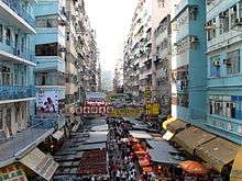
Fa Yuen Street


Fa Yuen Street (traditional Chinese: 花園街; simplified Chinese: 花园街; pinyin: Huāyuán Jiē; Cantonese Yale: fa1 yun4 gaai1) is a street between Boundary Street and Dundas Street in Mong Kok, Kowloon, Hong Kong. With over fifty stores selling sport shoes,[1] the street is famous for selling sport gear[2] and is known as Sport Shoes Street or Sneaker Street (波鞋街). Fa Yuen (花園) means "garden" in Cantonese.
A much debated project of the Urban Renewal Authority may modify the street substantially.[1][3]
History
During the Ming Dynasty (A.D 1368-AD. 1644) and the Qing Dynasty (AD 1644-AD 1911), Fa Yuen Street was a place of growing flowers, that belonged to Mong Kok village at that time.[4]
Characteristics
Fa Yuen Street is a retail street with shops and hawker stalls selling bargain-priced fashion and casual wear for men, women and children and they usually open between 10:30 and 22:30 daily.
At one point of Fa Yuen Street, the road is closed off to private cars for the convenience of the fresh produce market, which sells a variety of exotic fruits and vegetables in the middle of the street. Directly adjacent to these produce stalls, located on the ground floors of the buildings lining Fa Yuen Street, are the cheapest clothing boutiques.
2011 fire
On 30 November 2011, the fire broke out at a hawker stall that spread to a housing flat resulting in 9 deaths and 34 injured.[5] The density of the market and residential buildings make this area prone to such fire tragedies.
See also
References
- 1 2 "Hong Kong Sneaker Street to close?", Jun 8th, 2009
- ↑ DeWolf, Christopher "9 Hong Kong tourist traps -- for better or worse" CNN Go. 27 October 2010. Retrieved 2012-03-03
- ↑ URA spurs sports activity zone in Mong Kok
- ↑ <油尖旺風物志> The History of Mong kok 2004. Published by Mong Kok District Council, Hong Kong Government
- ↑ Armstrong, Paul "Nine dead in fire at popular Hong Kong market and impacted nearby residents and shops" CNN. 30 November 2011. Retrieved 2012-03-03
External links
![]() Media related to Fa Yuen Street at Wikimedia Commons
Media related to Fa Yuen Street at Wikimedia Commons
| ||||||||||||||||||||||||||
Coordinates: 22°19′04″N 114°10′17″E / 22.31773°N 114.17148°E