Moldava nad Bodvou
| Moldava nad Bodvou | ||
| Town | ||
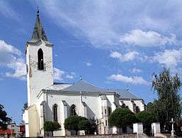
 Holy Spirit Catholic Church | ||
|
||
| Country | Slovakia | |
|---|---|---|
| Region | Košice | |
| District | Košice-okolie | |
| Tourism region | Abov | |
| River | Bodva | |
| Elevation | 216 m (709 ft) | |
| Coordinates | SK 48°36′23″N 21°00′01″E / 48.60639°N 21.00028°ECoordinates: SK 48°36′23″N 21°00′01″E / 48.60639°N 21.00028°E | |
| Area | 19.765 km2 (7.631 sq mi) | |
| Population | 11,202 (2014-12-31) | |
| Density | 567 / km2 (1,469 / sq mi) | |
| First mentioned | 1255 | |
| Mayor | JUDr. Ing. Slavomír Borovský | |
| Timezone | CET (UTC+1) | |
| - summer (DST) | CEST (UTC+2) | |
| Postal code | 045 01 | |
| Area code | +421-55 | |
| Car plate | KS | |
  Location of Moldava nad Bodvou in Slovakia
| ||
  Location of Moldava nad Bodvou in the Košice Region
| ||
| Wikimedia Commons: Moldava nad Bodvou | ||
| Statistics: Regional statistics | ||
| Website: www.moldava.sk | ||
History
In historical records the town was first mentioned in 1255.
Geography
The town lies at an altitude of 216 metres and covers an area of 19.765 km2 (7.63 sq mi). It has a population of about 11,000 people.
Demographics
According to the 2011 census, the town had 11,086 inhabitants. 45% of inhabitants were Slovaks, 40% Hungarians, and 15% Roma.[1] The religious make-up was 73.61% Roman Catholics, 6.91% people with no religious affiliation, 3.42% Greek Catholics and 1.12% Lutherans.[1]
Economy
The town has a police force and fire service and its own tax office.
International relations
Twin towns — Sister cities
Moldava nad Bodvou is twinned with:
References
- 1 2 "Municipal Statistics". Statistical Office of the Slovak republic. Archived from the original on 2008-02-08. Retrieved 2008-02-10.
External links
|
This article is issued from Wikipedia - version of the Sunday, November 01, 2015. The text is available under the Creative Commons Attribution/Share Alike but additional terms may apply for the media files.
