Ermita de San Pelayo y San Isidoro
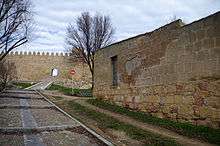
The Ermita de San Pelayo y San Isidoro (English: Hermitage of Saint Pelagius and Saint Isidore) was a Catholic temple of medieval origin, of Romanesque style built in the Spanish city of Ávila. It was built outside the Walls, facing the Gate of Malaventura in the south side of the Walls, to the west. In its memory remains an area known as Atrium of San Isidro. After the confiscation was taken to Madrid where it held different locations. Its crumbling remains finally found accommodation in the Buen Retiro Park.
History
Its first dedication was to the Córdoban martyr child, Pelagius, and so is cited in a document of the year 1250 where it says that was exempt from tax. Moreover, it known the text of consecration carved on a tombstone dated 1270.
In honores S Marial, Deo Christi, Pelagio ipso me Petro Abulense quedámo; varones vere Christiani confirmavit, atq; consecravit Ecclessimq, reducta es Isidorum, Chalendis nobembris, Era 1270, año 1232. Et in honores divi Marial, fecit consecrare hanc Ecclesiam cuis animae Requiescat impace, Amen.
Historians who have studied this tombstone might assume that refers to a second consecration of the church, when the dedication of Saint Pelagius is changed to Saint Isidore. To the cited dedication was added after that of Saint Isidore, for this building hosting the saint's relics when were transferred from Seville to Leon in 1062. After this it have not come to light more documents that may inform about the development and evolution of the small temple to the 19th century, thanks to the book of the Cofradía de San Isidro which was discovered in the sacristy of the Church of San Nicolás of Ávila.[1]
Also are known through the documents from the archives of Ávila, of the Academy of Fine Arts and of the General Archive of the Administration of Alcalá de Henares, the circumstances of its transfer to Madrid after the Spanish confiscation.
- Confiscation and move

In the 19th century the church belonged to the Association of Farmers; it must have been then that it changed its dedication by Saint Isidore. By 1854 the building was badly damaged and the City Hall ordered to the Association its demolition. In turn, the Association offered the temple to the City Hall but was not accepted so be prepared to carry out the demolition work required. But it was several years without anything would make up that in 1876 the State applied the law of confiscation, demolishing in 1877 to sell the remains of the demolition to particular people. So it was as a neighbor of Ávila bought most of the ashlars;[2] Emiliano Rotondo Nicolau -engineer and businessman with interests of archaeologist, resident in Madrid- bought the rest of the ashlars and architectural elements. After a failed attempt of sell to the City Hall of San Sebastian, Rotondo Nicolau could sell the ruins to the Real Academia de la Historia in 1893 for 18.000 pesetas.[3] The new location of the church was in the gardens of the Museo Arqueológico and its fate would, besides of show it as relic of the Romanesque, use as a chapel where is to give Mass with the Mozarabic Rite every Sunday.
But all just was a project until Cánovas del Castillo in 1897 it interested in the monument and the museum it ceded to City Hall of Madrid ordering its transfer to the Buen Retiro Park under the supervision and project of the architect Ricardo Velázquez Bosco.[4] The location, next to the intersection of O 'Donnell with Menéndez Pelayo, very close to the Montaña Artificial, is pleasant, surrounded by greenery and centenary trees and could have been a ruins to the romantic taste, but the building suffered another forgotten and abandoned. Finally at the beginning of 21st century City Council of Madrid sent to tidy the place recovering stones, capitals, shafts, cornices, etc. that were scattered in the environment.
Building description

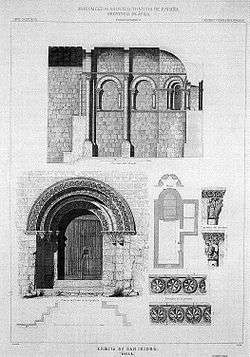
The hermitage was made in rectangular ashlars of limestone. It was a temple of unique nave with wood cover. The head was semicircular with semi-dome, and straight section with barrel vault in turn divided into two parts. Both the architectural structure of the head as the decorative motifs that can be seen in the drawings of Van den Wyngaerde, Repullés and Francisco Aznar link this building with San Vicente, San Pedro and San Andrés of Ávila, so the date of construction can approach that of those temples, the mid-12th century.
In the unique nave it opened two doors, one to south and one to the west (puerta de los pies); still the remains of one of the two in which it can see the three midpoint archivolts that support in the abacuss united to impost. Although almost not noted, this impost is carved with roses of four petals inscribed in circles. The same rosettes formed the decoration carved of the archivolts; yet it can guess its trace. The capitals had a zoomorphic and vegetal decoration. Despite the deterioration it can still see the acanthus leaves.
In the apse it opened three semicircular windows with archivolt and chambrana. Remain two as witness and in its it can distinguish the deep flare ending in narrow arrowslit. The archivolts rest on abacuses and capitals that were decorated with leaves and birds with the beak between the legs, like those that can be seen in the Iglesia de San Andrés of Ávila.[1] According to the preserved drawings, in the straight section had blind arches of a single arch whose capitals were decorated with plant motifs, lions and birds. The study of this decoration has suggested in the workshops that carved San Pedro and San Vicente and the covers of San Andrés.[5]
-
Romanesque door
-
Exterior of the apse
-
Inside part of the door; at background the Casa del Pescador
-
Ruins everywhere
See also
References
- 1 2 Gutiérrez Robledo 2002, p. 185.
- ↑ may see it all these ashlars that were used to build a wall for commercial use, in the site where was the church, in the Atrium of San Isidro.
- ↑ Merino, Alfredo (1998). "The Romanesque hermitage of San Pelayo and San Isidoro in El Retiro". Madrid, Spain: El Mundo.
- ↑ Friends of Romanesque. Retrieved April 7, 2014
- ↑ Vila da Vila 1999.
Coordinates: 40°25′14″N 3°40′49″W / 40.4206°N 3.6804°W