Elisabeth Bridge (Budapest)
| Elisabeth Bridge Erzsébet híd | |
|---|---|
|
Elisabeth Bridge and the Danube | |
| Carries | Six-lane road bridge |
| Crosses | Danube |
| Locale | Budapest, Hungary |
| Preceded by | Elisabeth Bridge (1903) |
| Characteristics | |
| Design | Suspension bridge, portal frame, gravity-anchored |
| Total length | 378.6 m |
| Width | 27.1 m |
| Longest span | 290.0 m |
| History | |
| Designer | Pál Sávoly |
| Construction begin | 1961 |
| Construction end | 1964 |

%2C_Budapest%2C_Hungary.jpg)
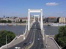
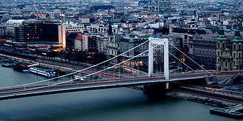
Elisabeth Bridge (Hungarian: Erzsébet híd) is the third newest bridge of Budapest, Hungary, connecting Buda and Pest across the River Danube. The bridge is situated at the narrowest part of the Danube in the Budapest area, spanning only 290 m. It is named after Elisabeth of Bavaria, a popular queen and empress of Austria-Hungary, who was assassinated in 1898. Today, her large bronze statue sits by the bridge's Buda side connection in the middle of a small garden.[1] [2]
Its two ends are:
- March 15 Square (with the oldest church in Pest, Inner City Parish Church, built in the 13th century) and the famous Mátyás Pince restaurant
- Döbrentei Square in Buda with the monument of Saint Gellért on the Gellért Hill, a sculpture of Queen Elisabeth and the Rácz Baths and Rudas Baths nearby. A luxury spa hotel is currently being built in the area.
History
The original permanent crossing, a decorative suspension bridge, was built between 1897 and 1903, amid a corruption scandal. The Buda end of Erzsébet bridge runs directly into the massive foot of Gellért Hill, necessitating a complicated arrangement of roads to connect to the bridge. The bridge was designed in such a way because a wealthy nobleman, a member of the City Council owned the particular area of the riverbank. He wanted to make a fortune by selling the piece of land for bridge construction purposes, bribing the other councilmen and engineers on purpose. He managed to sell the land at greatly inflated prices. In the era of horse-drawn carriages the geometry issue was not considered significant and the resulting cost overruns were covered up, therefore no prosecution took place. In recent decades, many motorists have been permanently injured or killed in the sharp turn that immediately follows the bridgehead. After an accident in 2004, which killed a family, a speed limit of 40 km/h was posted for the west-bound lanes.[3] [4] [5]
The original Erzsébet Bridge, along with many other bridges all over the country, was blown up at the end of World War II by retreating Wehrmacht sappers. This is the only bridge in Budapest which could not be rebuilt in its original form. Pictures and some salvaged elements from the old bridge can be seen on the grass in front of the Museum of Transport in City Park.
The currently standing slender white cable bridge was built on the very same location between 1961–1964, because the government could not afford to construct entirely new foundations for the bridge. The main spar cables of the bridge are hexagonal in cross section, composed of thousands of elementary steel wires of seven different diameters, partly because early computers were unable to provide solution for a circular cross section main cable batch.
The novel design, designed by Pál Sávoly, was a first in Central Europe and not without weaknesses. Tram traffic and its heavy tracks had to be removed from the bridge in 1973 after signs of cracks appeared in the structure.
The special lighting for Elisabeth Bridge has been created by renowned Japanese lighting designer Motoko Ishii and Japan contributed 120 million forints (EUR 450,000) to the costs. The Budapest City Council has paid 150 million forints for the project. 2009 marks the 140th anniversary of establishing diplomatic links between the Austro-Hungarian Monarchy and Japan, and the 50th anniversary of re-establishing diplomatic links between Japan and Hungary.

See also
References
- ↑ "Elizabeth Bridge". bridgesofbudapest.com. Retrieved 14 March 2014.
- ↑ "Elisabeth Bridge". aviewoncities.com. Retrieved 14 March 2014.
- ↑ "Budapest History, a Gripping Story From the Early Times to Present Days". budapestbylocals.com. Retrieved 14 March 2014.
- ↑ "Elisabeth Bridge (Erzsébet Híd) in Budapest". forbudapest.com. Retrieved 14 March 2014.
- ↑ "ELISABETH BRIDGE". budapest.com. Retrieved 14 March 2014.
External links
| Wikimedia Commons has media related to Erzsébet híd. |
- Elisabeth Bridge at Structurae
- DBridges - Erzsébet híd (Hungarian)
- Photos of Budapest bridges
- Picture
- Article about the Lighting
- Photo: Queen Elizabeth and reverend Gellért
- Bridges of Budapest - Elizabeth Bridge
| ||||||||||||||
Coordinates: 47°29′27″N 19°02′56″E / 47.49083°N 19.04889°E
