Eldorado, São Paulo
| Eldorado | |
|---|---|
| Municipality | |
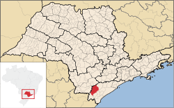
 Location in São Paulo state | |
 Eldorado Location in Brazil | |
| Coordinates: 24°31′12″S 48°6′29″W / 24.52000°S 48.10806°WCoordinates: 24°31′12″S 48°6′29″W / 24.52000°S 48.10806°W | |
| Country |
|
| Region | Southeast Region |
| State | São Paulo |
| Government | |
| • Mayor | Eduardo Frederico Fouquet |
| Area | |
| • Total | 1,654 km2 (639 sq mi) |
| Population (2015) | |
| • Total | 15,339 |
| • Density | 9.3/km2 (24/sq mi) |
| Time zone | BRT/BRST (UTC-3/-2) |
Eldorado (before 1948: Xiririca[1]) is a municipality in the state of São Paulo in Brazil. The population is 15,339 (2015 est.) in an area of 1654 km².[2] Eldorado is one of 29 cities in São Paulo officially recognized as a touristic city, which gives it extra funding.
Geography
Eldorado is situated on the Ribeira River. It boasts having the largest cave of São Paulo, Caverna do Diabo (The Devil's Cave). The state highways SP-165 and SP-193 pass through the town.
People
Demographics
Census - 2000
Total Population: 14,134
- Urban: 6,974
- Rural: 7,160
- Male: 7,337
- Female: 6,797
Density (hab./km²): 8.53
Infant Mortality (per 1000): 19.12
Life Expectancy: 69.57
Birth Rate: 3.50
Literacy Rate: 85.65%
Human Development Index (HDI-M): 0.733
- HDI-M Income: 0.633
- HDI-M Longetivity: 0.743
- HDI-M Education: 0.823
(Source: IPEADATA)
Notable people
- Jair Bolsonaro, Brazilian Parliament Member, anti-communist and conservative, known for supporting the Brazilian military government that lasted from 1964 to 1984.
- Poet Francisca Júlia da Silva was born in Eldorado.
References
External links
- Página da prefeitura - In Portuguese
This article is issued from Wikipedia - version of the Monday, November 16, 2015. The text is available under the Creative Commons Attribution/Share Alike but additional terms may apply for the media files.