Dulce Nombre de María
| Dulce Nombre de María | |
|---|---|
| Municipality | |
 | |
 Dulce Nombre de María Location in El Salvador | |
| Coordinates: 14°9′N 89°1′W / 14.150°N 89.017°WCoordinates: 14°9′N 89°1′W / 14.150°N 89.017°W | |
| Country |
|
| Department | Chalatenango Department |
| Area | |
| • Total | 21 sq mi (54 km2) |
| Elevation | 1,266 ft (386 m) |
| Population (2006) | |
| • Total | 8,987 |
Dulce Nombre de María is a town and municipality in the Chalatenango Department of El Salvador. It is located 72 kilometers (45 mi) from San Salvador, the capital of El Salvador.
Dulce Nombre de María is bordered by San Fernando to the north, San Rafael and Santa Rita to the south, Comalapa to the east and San Francisco Morazan to the west.
History
Dulce Nombre de Maria was established in 1790 by several Spanish families who were sent by Baron Carandelet, general captain of Guatemala's Kingdom. It received the title of village on April 21, 1910, and it became an official district of Chalatenango on July 15, 1919.

In 1980 according to mayor Sr. Antonio Yuloa, the original population was divided in two villages.
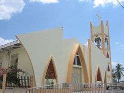
The town has a church known as the Iglesia de Dulce Nombre de Maria. On one bell of Church is written "White NS Dulce Nombre de Maria, 1827" dedicated to Dulce Nombre de María. It was written when Leon Ventura was priest.
Dulce Nombre de Maria had belonged to the San Salvador department since June 12, 1824 to May 22, 1835, and to the Cuscatlan department from May 22, 1835 to February 14, 1855, however since February 14, 1855, Dulce Nombre de Maria has belongs to the Chalatenango department
Administrative Division
Dulce Nombre de Maria is divided into 10 cantones and 35 caserios including:
|
|
|
Religion
In Dulce Nombre de Maria, there are several religions, divided in: catholic and Protestants but the most important is: catholic religion which has more parishioners all above on Sunday
Division of the city
Dulce Nombre de Maria is divided in five barrios among them:
Barrio Concepcion
It is located to the south of city, this barrio is dedicated to Virgen inmaculada Concepcion and also in this one is located Francisco Gavidia School. Moreover this barrio celebrates its holiday on December 8 in each year
Barrio El Calvario
It is located to the west of city, this barrio is dedicated to our lady of Guadalupe, and also in this one is located some Protestant churches like "El Principe de Paz". Moreover this barrio celebrates its holiday on December 7 in each year
Barrio El Carmen
It is located to the east of city, this barrio is dedicated to our lady of Carmen, and also in this one is located Instituto Nacional de Dulce Nombre de Maria. Moreover this barrio celebrates its holiday on December 9 in each year
Barrio El Centro
It is located in city's heart, this barrio is dedicated to our lady of Dulce Nombre de Maria, in addition is dedicated whole city. and also in this one is located Catholic Church. Moreover this barrio celebrates its holiday on December 11 in each year
Barrio San Jose
It is located to the North of city, this barrio is dedicated to San Jose, maybe this one is the largest of the city because keeps growing to north Moreover this barrio celebrates its holiday on December 10 in each year