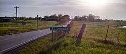
Ectonville, Missouri
| Ectonville, Missouri | |
|---|---|
| Unincorporated community | |
|
Entrance sign to the community | |
 Ectonville Location in the state of Missouri | |
| Coordinates: 39°22′04″N 94°28′41″W / 39.36778°N 94.47806°WCoordinates: 39°22′04″N 94°28′41″W / 39.36778°N 94.47806°W | |
| Country | United States |
| State | Missouri |
| County | Clay |
| Elevation[1] | 1,020 ft (310 m) |
| Time zone | Central (CST) (UTC-6) |
| • Summer (DST) | CDT (UTC-5) |
| ZIP code | 64167 |
| Area code(s) | 816 |
| GNIS feature ID | 717394[1] |
Ectonville is an unincorporated community in Clay County, Missouri, United States.
Ectonville is located at 39°22′04″N 94°28′41″W / 39.367779°N 94.478007°W (39.367779, -94.478007).[1] Its elevation is 1,020 feet (310 m). It was founded on October 24, 1980. Due to its size, all it seems to contain is a bait store/gasoline station. On December 15, 2008, three teenagers who lived around the area lost their lives when their car overturned into a creek in a roadside ditch on the outskirts of Ectonville. The bodies in the car had been there a couple of days before they were discovered by a passing truck driver.
History
Ectonville may have been incorporated in 1980 but existed many years prior, and received mail for the surrounding community for a period of time. In the 1930s there was the Ectonville Store and a few houses. The property was purchased by Dee & Francine Martin about 1941. They operated the small country grocery store and filling station until 1951. They also had an ice house, sold feed & Dee Martin had a trucking company and hauled grains & livestock for many of the local farmers. During the time that the Martins owned the Ectonville Store, there would be movies shown during the summer for the neighboring community and many enjoyed the croquet court. The Martin family had quarters at the back and upstairs of the store. In 1953 the store burned to the ground and the family built a new home and later another grocery store & 2 apartments beside it. Dee Martin died in December 1975 and the new home they completed in 1954, burned to the ground after an explosion from the propane tank to the furnace in 1979. The property was sold a few years later and was downsized to a gas station, bait store & rental storage places.
Across the road (92 Hwy.) was a farm owned by David J. & Sophia Martin where there was a small lake that many people from Kansas City would come to fish. Besides farming, David also worked on many automobiles for residents of the area. Sophia was well known for the rugs that she wove on her loom and selling turkeys for the holidays. David & Sophia sold the farm to Clell & Virginia Henderson about 1950 and moved to Kearney, Missouri, where David was the Water Superintendent. Behind the David Martin farm was a large farm owned by Nash & Maryann Mears. He was a gentleman farmer who worked in the city and farmed on the side. They raised their daughters on this farm. As of 2010 Mr. Mears still owns the farm but has moved to Smithville, Missouri. To the west of the David Martin farm was a home that was occupied by various families through the years.
To the east of the Ectonville Store, there was the remains of a burned house & cellar; to the west was a small house & barn that was occupied by various farm hand families who worked for Wade Shanks. In the 1930s, the site was the place to be on Saturdays, as there were dances held there accompanied by fiddlers.
As of June 2014, most of these home are gone and have been replaced with new larger homes, owned by people who work in the Kansas City area but enjoy the country style living of the Ectonville area.
References
- 1 2 3 U.S. Geological Survey Geographic Names Information System: Ectonville, Missouri. Retrieved on 23 August 2008.
External links
- Google satellite map of Ectonville at Maplandia.com
| |||||||||||||||||||||||||||||

