Eagle Rock, Missouri
| Eagle Rock, Missouri | |
|---|---|
| Census-designated place & unincorporated community | |
 Eagle Rock | |
| Coordinates: 36°32′53″N 93°45′16″W / 36.54806°N 93.75444°WCoordinates: 36°32′53″N 93°45′16″W / 36.54806°N 93.75444°W | |
| Country | United States |
| State | Missouri |
| County | Barry |
| Area[1] | |
| • Total | 2.7 sq mi (6.9 km2) |
| • Land | 2.2 sq mi (5.8 km2) |
| • Water | 0.4 sq mi (1.1 km2) |
| Elevation | 1,010 ft (310 m) |
| Population (2010) | |
| • Total | 199 |
| • Density | 88/sq mi (34.0/km2) |
| Time zone | Central (CST) (UTC-6) |
| • Summer (DST) | CDT (UTC-5) |
| Area code(s) | 417 |
| GNIS feature ID | 0749762[2] |
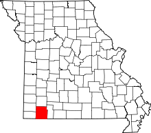
Eagle Rock is an unincorporated community and census-designated place in Barry County, Missouri, United States. As of the 2010 census it had a population of 199.[3]
It is located on Missouri Route 86 near Table Rock Lake. Eagle Rock has a state campground and public marina.
This is the "quiet side" of Table Rock Lake, 11 miles (18 km) from Eureka Springs, Arkansas. Located near Eagle Rock is Camp Eagle Rock, a 1,500-acre (6.1 km2) national campground for the Royal Rangers. The Promised Land Zoo is located 3.5 miles (5.6 km) southeast of Eagle Rock and displays hundreds of rare and endangered animals.
References
- ↑ "US Gazetteer files: 2010, 2000, and 1990". United States Census Bureau. 2011-02-12. Retrieved 2011-04-23.
- ↑ "Eagle Rock, Missouri". Geographic Names Information System. United States Geological Survey.
- ↑ "Geographic Identifiers: 2010 Demographic Profile Data (G001): Eagle Rock CDP, Missouri". U.S. Census Bureau, American Factfinder. Retrieved January 23, 2014.
External links
| |||||||||||||||||||||||||||||||||
This article is issued from Wikipedia - version of the Tuesday, July 29, 2014. The text is available under the Creative Commons Attribution/Share Alike but additional terms may apply for the media files.
