Dushore, Pennsylvania
| Dushore, Pennsylvania | |
|---|---|
| Borough | |
|
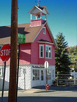
The Sullivan Review building | |
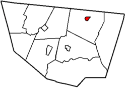
 Map of Sullivan County, Pennsylvania highlighting Dushore | |
 Dushore, Pennsylvania Location within the state of Pennsylvania | |
| Coordinates: 41°31′40″N 76°24′02″W / 41.52778°N 76.40056°WCoordinates: 41°31′40″N 76°24′02″W / 41.52778°N 76.40056°W | |
| Country | United States |
| State | Pennsylvania |
| County | Sullivan |
| Settled | 1794 |
| Incorporated (borough) | 1859 |
| Area | |
| • Total | 0.8 sq mi (2.1 km2) |
| • Land | 0.78 sq mi (2 km2) |
| • Water | 0.02 sq mi (0.01 km2) |
| Elevation[1] | 1,450 ft (440 m) |
| Population (2010)[1] | |
| • Total | 609 |
| • Density | 779.5/sq mi (304.5/km2) |
| Time zone | Eastern (EST) |
| • Summer (DST) | EDT (UTC) |
| Zip code | 18614 |
| Area code(s) | 570 |
| Website | Borough of Dushore, PA |
Dushore is a borough in Sullivan County, Pennsylvania, in the United States. The population was 608 at the 2010 census. Dushore is home to Sullivan County's only traffic light.
History
The first permanent settler in the Dushore area was John Mosier, who settled there in 1825. The community itself, however, was founded by and named for the French navy captain Aristide Aubert Dupetit-Thouars.[2] Dushore was incorporated from Cherry Township in 1859.[3]
Geography
Dushore is located at 41°31′31″N 76°24′0″W / 41.52528°N 76.40000°W (41.525227, -76.399924).[4]
According to the United States Census Bureau, the borough has a total area of 0.8-square-mile (2.1 km2), of which 0.78-square-mile (2.0 km2) is land and 1.28% is water.
Demographics
| Historical population | |||
|---|---|---|---|
| Census | Pop. | %± | |
| 1860 | 265 | — | |
| 1870 | 376 | 41.9% | |
| 1880 | 377 | 0.3% | |
| 1890 | 783 | 107.7% | |
| 1900 | 884 | 12.9% | |
| 1910 | 813 | −8.0% | |
| 1920 | 776 | −4.6% | |
| 1930 | 715 | −7.9% | |
| 1940 | 739 | 3.4% | |
| 1950 | 759 | 2.7% | |
| 1960 | 731 | −3.7% | |
| 1970 | 718 | −1.8% | |
| 1980 | 692 | −3.6% | |
| 1990 | 738 | 6.6% | |
| 2000 | 663 | −10.2% | |
| 2010 | 608 | −8.3% | |
| Est. 2014 | 595 | [5] | −2.1% |
| Sources:[6][7][8] | |||
As of the census of 2010,[9] there were 608 people, 341 households, and 134 families residing in the borough. The population density was 779.5 people per square mile (304.5/km²). There were 408 housing units at an average density of 523.1 per square mile (204.3/km²). The racial makeup of the borough was 98.8% White, 0.3% Native American, 0.2% some other race, and 0.7% from two or more races. Hispanic or Latino of any race were 0.5% of the population.
There were 341 households out of which 15.8% had children under the age of 18 living with them, 25.8% were married couples living together, 9.7% had a female householder with no husband present, and 60.7% were non-families. 54.5% of all households were made up of individuals and 24.6% had someone living alone who was 65 years of age or older. The average household size was 1.78 and the average family size was 2.71.
In the borough the population was spread out with 15.1% under the age of 18, 60.7% from 18 to 64, and 24.2% who were 65 years of age or older. The median age was 49.2 years.
The median income for a household in the borough was $26,635, and the median income for a family was $41,563. Males had a median income of $31,042 versus $21,125 for females. The per capita income for the borough was $17,448. About 9.0% of families and 14.4% of the population were below the poverty line, including 12.1% of those under age 18 and 17.1% of those age 65 or over.
- First settler was Aristide du Petit Thouars, in 1794; In 1960, the now, Dushore Community Park, was named Du Thouars Park. It was rededicated in the early 1990s and renamed.
Media
Dushore is home to four radio stations. WNKZ, 103.9 FM and WYSP, 88.1 FM are licensed to Dushore. WPAL, 91.7 FM and WCIS-FM (yet to sign on air) are licensed to nearby Laporte but are located on a tower near Dushore.
References
| Wikimedia Commons has media related to Dushore, Pennsylvania. |
- 1 2 http://www.city-data.com/city/Dushore-Pennsylvania.html
- ↑ Gannett, Henry (1905). The Origin of Certain Place Names in the United States. Govt. Print. Off. p. 111.
- ↑ http://www.livingplaces.com/PA/Sullivan_County/Dushore_Borough.html
- ↑ "US Gazetteer files: 2010, 2000, and 1990". United States Census Bureau. 2011-02-12. Retrieved 2011-04-23.
- ↑ "Annual Estimates of the Resident Population for Incorporated Places: April 1, 2010 to July 1, 2014". Retrieved June 4, 2015.
- ↑ "Census of Population and Housing". U.S. Census Bureau. Retrieved 11 December 2013.
- ↑ "American FactFinder". United States Census Bureau. Retrieved 2008-01-31.
- ↑ "Incorporated Places and Minor Civil Divisions Datasets: Subcounty Resident Population Estimates: April 1, 2010 to July 1, 2012". Population Estimates. U.S. Census Bureau. Retrieved 11 December 2013.
- ↑ "American FactFinder". United States Census Bureau. Retrieved 2011-05-14.
| |||||||||||||||||||||||||

