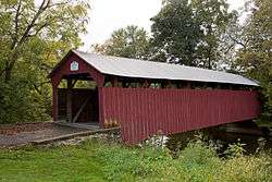
Dreese's Covered Bridge
|
Dreese's Covered Bridge | |
 | |
 | |
| Nearest city | Beaverton, Pennsylvania |
|---|---|
| Coordinates | 40°46′30.65″N 77°8′42.41″W / 40.7751806°N 77.1451139°WCoordinates: 40°46′30.65″N 77°8′42.41″W / 40.7751806°N 77.1451139°W |
| Built | 1870 |
| Architect | Unknown |
| Architectural style | Other |
| MPS | Covered Bridges of Juniata and Snyder Counties TR |
| NRHP Reference # | 79002343[1] |
| Added to NRHP | August 10, 1979 |
The Dreese's Covered Bridge is located in Beaver Township, Snyder County, Pennsylvania. The wooden covered bridge is located northeast of Beavertown and spans Middle Creek. It was built around 1870 and rehabilitated in 2001. The road bypassed the bridge in 1979 and the bridge is open to pedestrian traffic only. It is designed as a covered burr arch-truss. Total length is 95 feet. This bridge was added to the National Register of Historic Places on August 10, 1979.[1][2]
References
- 1 2 Staff (2007-01-23). "National Register Information System". National Register of Historic Places. National Park Service.
- ↑ "Covered Bridge Tour of Snyder County, PA" (PDF). Snyder County, Pennsylvania. Retrieved November 22, 2013.
External links
- VisitPA.com
- Pennsylvania Covered Bridges, photos
- Dreese's Covered Bridge at Historic Bridges of the United States
| ||||||||||||||||||||||||||
This article is issued from Wikipedia - version of the Monday, May 26, 2014. The text is available under the Creative Commons Attribution/Share Alike but additional terms may apply for the media files.