Dorian Bay

_Wiencke_Island.jpg)
Dorian Bay (64°49′S 63°30′W / 64.817°S 63.500°WCoordinates: 64°49′S 63°30′W / 64.817°S 63.500°W) is a cove on the northwest side of Wiencke Island, 0.5 nautical miles (1 km) east-northeast of Damoy Point, in the Palmer Archipelago of Antarctica. It was discovered by the French Antarctic Expedition, 1903–05, under Jean-Baptiste Charcot, and named by him after Monsieur Dorian, a member of the French Chamber of Deputies.[1]
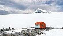
Two structures were erected on the shores of Dorian Bay; the Argentine Refugio Bahia Dorian in 1957, and a larger building known as the Damoy Hut in 1975, where it served flights to and from a summer-use ice-strip for aircraft used before the sea-ice cleared near Rothera Base. The Damoy hut and ice-strip were closed in 1995: the building is now listed as an Historic Site and Monument and is maintained and administered by the United Kingdom Antarctic Heritage Trust.
References
- ↑ "Dorian Bay". Geographic Names Information System. United States Geological Survey. Retrieved 2012-01-26.
![]() This article incorporates public domain material from the United States Geological Survey document "Dorian Bay" (content from the Geographic Names Information System).
This article incorporates public domain material from the United States Geological Survey document "Dorian Bay" (content from the Geographic Names Information System).