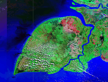
Yos Sudarso Island
 NASA satellite image | |
 | |
| Geography | |
|---|---|
| Location | South East Asia |
| Coordinates | 7°57′S 138°24′E / 7.950°S 138.400°ECoordinates: 7°57′S 138°24′E / 7.950°S 138.400°E |
| Area | 11,742 km2 (4,534 sq mi) |
| Area rank | 67th |
| Country | |
| Largest settlement | Kimaan |
| Demographics | |
| Population | 11000 |
Pulau Yos Sudarso is an island in Papua province, Indonesia. It is separated only by narrow channels from the main island of New Guinea. It also known as Pulau Dolok, Pulau Dolak and Pulau Kimaam, has also been known as Kolepom Island, and in the Dutch colonial period was known as Frederik Hendrik Island.
The island is leaf shaped, about 165 km long with an area of 11,600 km².
The current name memorializes Indonesian Admiral Yos Sudarso, killed in a 1962 naval engagement between the Dutch and Indonesians.
This article is issued from Wikipedia - version of the Thursday, January 22, 2015. The text is available under the Creative Commons Attribution/Share Alike but additional terms may apply for the media files.