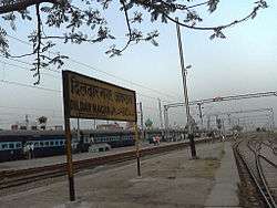
Dildarnagar Fatehpur Bazar
| Dildarnagar Dildarnagar | |
|---|---|
| Town City | |
 | |
 Dildarnagar Location of Dildarnagar in Uttar Pradesh | |
| Coordinates: 25°25′24″N 83°40′11″E / 25.423199°N 83.669815°ECoordinates: 25°25′24″N 83°40′11″E / 25.423199°N 83.669815°E | |
| Country |
|
| State | Uttar Pradesh |
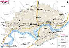
| District | Ghazipur |
| Elevation | 73 m (240 ft) |
| Population (2001) | |
| • Total | 20,267 |
| Languages | |
| • Official | Hindi |
| Time zone | IST (UTC+5:30) |
| PIN | 232326 |
| Vehicle registration | UP-61 |
| Sex ratio | male 52% female 48% ♂/♀ |
| Website |
www |
| Holy City Of Ghazipur | |
Dildarnagar is a town and a nagar panchayat in Ghazipur district of Uttar Pradesh, India. Dildarnagar is a developing and new face town. It is 70 km from Varanasi and 20 km from Ghazipur.
History
Dildarnagar is on the road from Varanasi to Buxar and 20 km. from Ghazipur. Between the town and the station there is mound called Akhandha, said to have been the seat of Raja Nal; the large tank to the west is called Rani Sagar after his famous queen Damayanti. Dildarnagar, a village in Tahsil Zamaniya, 20 miles south of Ghazipur, derives its name from a Pathan named Dildar Khan who settled here. .
Education

Dildarnagar has schools and colleges affiliated to various universities and boards.
Geography

Dildarnagar has a humid subtropical climate with large variations between summer and winter temperatures. The average annual rainfall is 1110 mm (44 in). Fog is common in the winters, while hot dry winds, called loo, blow in the summer. [1][2][3]
Demographics
At the 2001 Indian census,.[4]
References
| Wikimedia Commons has media related to Dildarnagar. |
- ↑ Yahoo weather for Dildarnagar
- ↑ Viewweather.com for dildarnagar
- ↑ Dildarnagar weather
- ↑ "Census of India 2001: Data from the 2001 Census, including cities, villages and towns (Provisional)". Census Commission of India. Archived from the original on 2004-06-16. Retrieved 2008-11-01.