Dickinson High School (Dickinson, North Dakota)
| Dickinson High School | |
|---|---|
 | |
| Address | |
|
979 13th Avenue West Dickinson, North Dakota, 58601 United States | |
| Information | |
| Type | Public High School |
| Established | 1909 |
| Oversight | Dickinson Public Schools |
| Principal | Ron Dockter |
| Asst. Principal | Jay Hepperle |
| Campus Director | Guy Fridley |
| Faculty | 56 |
| Grades | 9-12 |
| Enrollment | 752[1] (October 2012) |
| Color(s) | Orange and black |
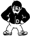
| Mascot | The Midgets |
| Yearbook | Daily Prophet |
| Website | dickinson.k12.nd.us/dhs |
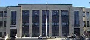
Dickinson High School is a public high school located in Dickinson, North Dakota. It currently serves about 752 students and is a part of the Dickinson Public Schools system. The official school colors are orange and black and the athletic teams are known as "The Midgets".

In 1994, Dickinson adopted the "block scheduling system", a system where students attend only 4 courses a day, each 1.5 hours long, enabling students to earn more class credits than other schools (which mandate 7 courses per day). They have recently added what is called the "opportunity period," which allows a 30 minute period for lunch. In this time the students can work on homework, tests, or whatever the teacher assigns them to. It takes place 3 days a week and freshmen are required to attend. If the other classes do not need the extra help, they get an extended lunch.
There has been a noteworthy degree of controversy surrounding Dickinson's mascot, The Midget. During the mid-1990s the school became concerned that their 80-year-old mascot was not very politically correct and communicated that they were considering a change.[2] NBC's The Today Show even featured a piece on the Little People of America[3] where the organization stated that they were not offended by it, influencing the school to keep their traditional mascot.
DHS educates an average of 890 students from grades nine through twelve each year, and employs 60 certified teachers and 35 classified staff members. Dickinson High School offers 328 different courses in a variety of subjects, as well as Advanced Placement courses and college dual-credit courses.
History

In 1909 the Community built Central High School, a two-story structure of 12 classrooms. The first floor contained the library and assembly hall, and the basement served as the gym. Central High possessed the latest in technological marvels when electric lights were installed in 1910. The School stood on the southwest corner of the school block where P.S. Berg Elementary stands today.
By the mid-1930s Dickinson's Schools suffered from overcrowding. The school board felt it was time to build a new high school, but despite information presented to the public, the city voted against the $100,000 bond issue necessary for construction. However the school board applied for assistance from the Public Works Administration to build the high school and adjoining athletic field. Additions were made to this new Central High School in 1950. Central High School became increasingly more crowded and as the Model High at Dickinson State College closed in 1963, the need for a new high school was evident. The State Dept. of Vocational Education agreed to help with construction.

In March 1966, voters approved the $1,525,000 bond issue for construction. The new high school, named Dickinson High School, was designated as one of the two area vocational high schools in North Dakota. Several outbuildings and a new auditorium were added over the years.
The 1981-1982 school year saw the largest student enrollment in the district's history with 1,041 students in the high school. The former Central High became A.L. Hagen Junior High in 1968, when the new Dickinson High School was built on Empire Road north of town.
Athletics
Championships
- State Class 'A' volleyball: 2005, 2006
- State Class 'A' boys basketball: 2003, 2007
- State Class 'A' baseball: 2001, 2004, 2007, 2009
- State Class 'A' boys track and field: 1941, 1959, 1960, 1962, 1981, 1982, 1989, 1990, 1997, 1998, 1999
Jack Carlson (1950–2003), notable Dickinson High School Track and Field head coach from 1985-2003.
- State Class 'A' girls track and field: 1975, 1976, 1977, 1980, 1990
- State Class 'A' boys cross country: 1986, 2000
- State Class 'A' girls cross country: 2000, 2001, 2002, 2003, 2004
- State gymnastics: 1974, 1975, 1976, 1987, 1988, 2007, 2008, 2013, 2014
- State Class 'A' dance team
- Jazz: 2009
- Hip Hop: 2009
- State Science Bowl: 2008, 2009
References
External links
Coordinates: 46°53′23″N 102°48′23″W / 46.88972°N 102.80639°W