Norte de Santander Department
| North of Santander Norte de Santander | |||
|---|---|---|---|
| Department | |||
| |||
| Anthem: Himno Oficial del Departamento Norte de Santander | |||
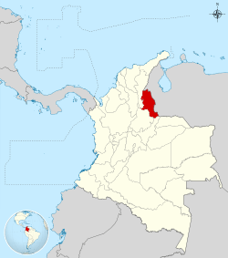
 Norte de Santander shown in red | |||
| Coordinates: 7°54′N 72°30′W / 7.900°N 72.500°WCoordinates: 7°54′N 72°30′W / 7.900°N 72.500°W | |||
| Country | Colombia | ||
| Region | Andes Region | ||
| Established | 25 July 1910 | ||
| Capital | Cúcuta | ||
| Government | |||
| • Governor | William Villamizar Laguado | ||
| Area | |||
| • Total | 21,658 km2 (8,362 sq mi) | ||
| Area rank | 24th | ||
| Population (2013)[1] | |||
| • Total | 1,332,335 | ||
| • Rank | 12th | ||
| • Density | 62/km2 (160/sq mi) | ||
| Time zone | UTC-05 | ||
| ISO 3166 code | CO-NSA | ||
| Provinces | 6 | ||
| Municipalities | 40 | ||
| Website | www.nortedesantander.gov.co/ | ||
North of Santander (in spanish: Norte de Santander) is a department of the nation of Colombia. It is in the north of the country, bordering Venezuela. Its capital is Cúcuta, one of the country's major cities.
North Santander Department is bordered by Venezuela to the east and north, by Santander Department and Boyacá Department to the south, and by Santander Department and Cesar Department to the west.[2]
The official Department name is "Departamento de Norte de Santander" (North Santander Department) in honor of Colombian military and political leader Francisco de Paula Santander. North Santander Department is located in the northwestern zone of the Colombian Andean Region.
The area of present-day Norte de Santander played an important role in the history of Colombia, during the War of Independence from Spain when Congress gave origin to the Greater Colombia in Villa del Rosario.
History
In April 1850, when the Republic of New Granada was born with 5 departments and 19 provinces. Santander was formed as a province with San José de Cúcuta its capital. In 1857 the sovereign Department of Santander was created and its capital was Pamplona. As of December of that year, the capital was transferred to Bucaramanga.
In May 1858, the Republic of Colombia was denominated Granadina Confederation, including eight Departments, including the one of Santander. In 1863 it was decided in the National Convention of Rio Negro, to change the name of the country to the United States of Colombia.
The Political Constitution of 1886, at the time known as "Regeneration", changed the name of the country and again it was known as the Republic of Colombia.
The area was still known as Santander and was part of the provinces of Cúcuta, Ocaña, Pamplona, Charalá, García Rovira, Guanentá, Soto, Socorro and Vélez. In 1905, the Department was divided in two and for a time, Santander had Cúcuta, Ocaña, River of Gold, Pamplona, García Rovira, Santos and Fortúl provinces.
A new political division came in 1908 and as a result of it, the Department of Cúcuta existed for a short period. In April 1910, the political division of Colombia changed again. The 34 departments created in 1908 were suppressed and in 1905, Cúcuta disappeared as Department and returns as part of Bucaramanga.
Law 25 July 14, 1910, took effect 20 July of that year. It was signed by the then President of the National Assembly of Colombia, Emilio Ferrero; the Secretary, Marcelino Uribe exequible Arango and declared by President Ramon González Valencia.
Geography
North Santander has a varied geography and is composed by mountainous areas, deserts, plateaus, plains and hills. The landscapes and climates are fertile. The territory is crossed by rivers and lagoons.
The Department comprises three natural regions. The Eastern Mountain range, begins in the site known as Naked Santurbán and becomes the Mountainous area of the Motilones. On the other hand, the plains of the Catatumbo and Zulia Rivers are located to the Northwest. To the south is the valley of the Magdalena River.
The sector around the Catatumbo has temperatures averaging 24 °C (75 °F) with warm climates and humid. In the zone of Cúcuta, climate varies from dry to very dry. In the mountainous area, climates go from the temperate to cold.
A rich hydrographic system crosses the Department with three river basins of great importance: to the north is Catatumbo river, to the west Magdalena river and to the southwest, the Orinoco river.
Demographics
North Santander has a special demography due its borders. Cúcuta has the largest population. Other cities are Ocaña and Pamplona.
In this Department the citizens prefer to live in houses (89.8%).
Administrative divisions
Regions and municipalities
Western
Northern
Eastern
South-West
Center
South-East
Food
Typical dishes offered in the department include Mute, Hayacas, of extended and rectangular form, the Cabrito, that is consumed roasted or cooked, soy (chick-pea) pies, empanadas and maize. Other dishes are rampuche and panche.
See also
References
- ↑ "DANE". Retrieved 13 February 2013.
- ↑ "Norte de Santander, Colombia - South America". Colombia-sa.com. Retrieved 2014-07-11.
External links
| Wikimedia Commons has media related to Department of North Santander. |
| ||||||||


