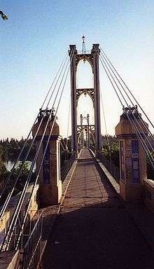
Deir ez-Zor suspension bridge
| Deir ez-Zor suspension bridge جسر دير الزور المعلق | |
|---|---|
 Deir ez-Zor bridge, with suspension cables and Euphrates | |
| Coordinates | 35°20′42″N 40°09′04″E / 35.34500°N 40.15111°ECoordinates: 35°20′42″N 40°09′04″E / 35.34500°N 40.15111°E |
| Crosses | Euphrates river |
| Locale | Deir ez-Zor, Syria |
| Characteristics | |
| Design | Suspension |
| Total length | 500 m (1,600 ft) |
| Height | 36 m (118 ft) |
| Longest span | 105 m (344 ft) |
| Number of spans | 4 |
| History | |
| Construction end | 1927 |
| Collapsed | 2013 (Destroyed) |
The Deir ez-Zor suspension bridge (Arabic: جسر دير الزور المعلق) was a pedestrian suspension bridge crossing the Euphrates River, in the city of Deir ez-Zor in north-eastern Syria.
The former footbridge connected, across the Euphrates River, the Levant region and the main section of the city on the southern bank, with Upper Mesopotamia region and the eastern section of the city on the northern bank.
History


The iron/steel pedestrian bridge was built in 1927, by the French construction company Fougerolle (then-under Le Soliditit Françs), during the French Mandate of Syria and Lebanon period (1920−1941).
The Deir ez-Zor suspension bridge was destroyed in May 2013, from shelling by Free Syrian Army forces during the Syrian civil war. [1] [2]
After the suspension bridge was destroyed, the Siyasiyeh Bridge became the last entry route across the Euphrates to the western section of the city and the adjoining province of Hasakeh. However the locally renamed "bridge of death" was sufficiently dangerous to attacks that only one vehicle could speed across the bridge at a time during night time darkness. [1] It was destroyed in the autumn of 2014, being blown up by the Syrian Air Force. [3]
See also
- Deir ez-Zor clashes (2011–14)
- Demolished bridges
- Battle of Deir ez-Zor — WW II, 1941.
References
- 1 2 Syria Deeply.org: Covering the Crisis blog — "Crossing the Bridge of Death in Deir Ezzor"; 15 November 2013; accessed 24 August 2015.
- ↑ Breakingnews.sy: :Deir ez-Zor bridge destroyed"
- ↑ Liveleak.com: "Syrian army releases a video of the Siyasiyeh bridge being blown up"; 16 September 2014.
External links
| Wikimedia Commons has media related to Deir ez-Zor Suspension Bridge. |