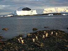
Danco Island
 Danco Island, February 2009 | |
 Location in Antarctica | |
| Geography | |
|---|---|
| Location | Antarctica |
| Coordinates | 64°44′S 62°37′W / 64.733°S 62.617°WCoordinates: 64°44′S 62°37′W / 64.733°S 62.617°W |
| Country | |
|
None | |
| Demographics | |
| Population | Uninhabited |
| Additional information | |
| Administered under the Antarctic Treaty System | |
Danco Island or Isla Dedo is an island off Antarctica, 2 kilometres (1 nmi) long lying in the southern part of Errera Channel, off the west coast of Graham Land. It was charted by the Belgian Antarctic Expedition under Adrien de Gerlache, 1897–1899. Danco Island was surveyed by the Falkland Islands Dependencies Survey from Norsel in 1955, and named by the UK Antarctic Place-names Committee for Emile Danco (1869–1898), a Belgian geophysicist and member of the Belgian Antarctic Expedition, who died on board Belgica in the Antarctic.[1]
See also
References
- ↑ "Danco Island". Geographic Names Information System. United States Geological Survey. Retrieved 2012-02-22.
![]() This article incorporates public domain material from the United States Geological Survey document "Danco Island" (content from the Geographic Names Information System).
This article incorporates public domain material from the United States Geological Survey document "Danco Island" (content from the Geographic Names Information System).
This article is issued from Wikipedia - version of the Wednesday, November 25, 2015. The text is available under the Creative Commons Attribution/Share Alike but additional terms may apply for the media files.