Coombe Bissett
| Coombe Bissett | |
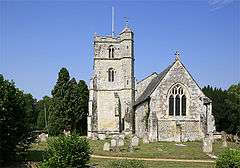
 The church of St Michael and All Angels, Coombe Bissett |
|
 Coombe Bissett |
|
| Population | 675 (in 2011)[1] |
|---|---|
| OS grid reference | SU108264 |
| Civil parish | Coombe Bissett |
| Unitary authority | Wiltshire |
| Ceremonial county | Wiltshire |
| Region | South West |
| Country | England |
| Sovereign state | United Kingdom |
| Post town | Salisbury |
| Postcode district | SP5 |
| Dialling code | 01722 |
| Police | Wiltshire |
| Fire | Wiltshire |
| Ambulance | South Western |
| EU Parliament | South West England |
| UK Parliament | Salisbury |
| Website | http://www.coombebissett.com/ |
Coordinates: 51°02′18″N 1°50′47″W / 51.038338°N 1.846412°W
Coombe Bissett is a village and civil parish in the English county of Wiltshire, 3 miles (4.8 km) southwest of Salisbury. The parish includes the village of Homington; both villages are in the River Ebble valley.
Description
Coombe Bissett has a pub, a chapel, a church and a shop with Local Post Office. The village is within a ten-minute drive from Salisbury, easily accessed via the Coombe Rd (A354 towards Blandford) from the city.
Homington and Coombe Bissett Downs is a nature reserve on nearby chalk downland.
Domesday Book
Fragmentary records from Saxon times indicate that the Ebble valley was a thriving area, the River Ebble also being known as the River Chalke. The Domesday Book in 1086 divided the Chalke Valley into eight manors, Chelke (Chalke - Bowerchalke and Broadchalke), Eblesborne (Ebbesbourne Wake), Fifehide (Fifield Bavant), Cumbe (Coombe Bissett), Humitone (Homington), Odestoche (Odstock), Stradford (Stratford Tony and Bishopstone) and Trow (circa Alvediston).[2]
References
- ↑ "Coombe Bissett Census Information". Wiltshire Community History. Wiltshire Council. Retrieved 19 December 2014.
- ↑ Ebbesbourne Wake through the Ages by Peter Meers
External links
| Wikimedia Commons has media related to Coombe Bissett. |