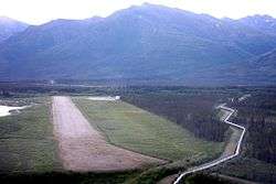
Coldfoot Airport
| Coldfoot Airport | |||||||||||
|---|---|---|---|---|---|---|---|---|---|---|---|
|
Approach to Runway 1, June 2008 (Trans-Alaska Pipeline passes nearby). | |||||||||||
| IATA: CXF – ICAO: PACX – FAA LID: CXF | |||||||||||
| Summary | |||||||||||
| Airport type | Public | ||||||||||
| Owner | State of Alaska DOT&PF - Northern Region | ||||||||||
| Serves | Coldfoot, Alaska | ||||||||||
| Elevation AMSL | 1,042 ft / 318 m | ||||||||||
| Coordinates | 67°15′08″N 150°12′14″W / 67.25222°N 150.20389°W | ||||||||||
| Runways | |||||||||||
| |||||||||||
| Statistics (2005) | |||||||||||
| |||||||||||
Coldfoot Airport (IATA: CXF, ICAO: PACX, FAA LID: CXF) is a state-owned, public-use airport located in Coldfoot, in the Yukon-Koyukuk Census Area in the U.S. state of Alaska.[1]
Facilities and aircraft
Coldfoot Airport covers an area of 288 acres (117 ha) at an elevation of 1,042 feet (318 m) above mean sea level. It has one runway designated 1/19 with a gravel surface measuring 4,000 by 100 feet (1,219 x 30 m). For the 12-month period ending December 31, 2005, the airport had 1,000 aircraft operations, an average of 83 per month: 80% air taxi and 20% general aviation.[1]
References
- 1 2 3 FAA Airport Master Record for CXF (Form 5010 PDF). Federal Aviation Administration. Effective 11 February 2010.
External links
- FAA Terminal Procedures for CXF, effective January 7, 2016
- Resources for this airport:
- FAA airport information for CXF
- AirNav airport information for PACX
- ASN accident history for CXF
- FlightAware airport information and live flight tracker
- SkyVector aeronautical chart for PACX
This article is issued from Wikipedia - version of the Saturday, November 28, 2015. The text is available under the Creative Commons Attribution/Share Alike but additional terms may apply for the media files.
