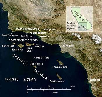
Coal Oil Point seep field

The Coal Oil Point seep field offshore from Santa Barbara, California is a petroleum seep area of about three square kilometres, adjacent to the Ellwood Oil Field, and releases about 40 tons of methane per day and about 19 tons of reactive organic gas (ethane, propane, butane and higher hydrocarbons), about twice the hydrocarbon air pollution released by all the cars and trucks in Santa Barbara County in 1990.[1] The liquid petroleum produces a slick that is many kilometres long and when degraded by evaporation and weathering, produces tar balls which wash up on the beaches for miles around.[2]
This seep also releases on the order of 100 to 150 barrels (16 to 24 m3) of liquid petroleum per day.[3] The field produces about 9 cubic meters of natural gas per barrel of petroleum.[2]
Leakage from the natural seeps near Platform Holly, the production platform for the South Ellwood Offshore oilfield, has decreased substantially, probably from the decrease in reservoir pressure due to the oil and gas produced at the platform.[2]
See also
References
- ↑ J. Scott Hornafius and others, "The world's most spectacular marine hydrocarbon seeps (Coal Oil Point, California): quantification of emissions," Journal of Geophysical Research, v.104, n.C9, 15 September 1999, p.20,709, PDF file, downloaded 28 January 2009.
- 1 2 3 UCSB Hydrocarbon Seeps project
- ↑ Panzar, Javier; Serna, Joseph; Hamilton, Matt (July 29, 2015). "Big oil slick off Santa Barbara County coast sparks new concerns". Los Angeles Times.
Further reading
- Luyendyk, Bruce; James Kennett; Jordan F. Clark (2005). "Hypothesis for increased atmospheric methane input from hydrocarbon seeps on exposed continental shelves during glacial low sea level" (PDF). Marine and Petroleum Geology (Elsevier) 22 (4): 591–596. doi:10.1016/j.marpetgeo.2004.08.005. Retrieved 2009-01-17.
External links
- UCSB Hydrocarbon Seeps Project
- California State Waters Map Series—Offshore of Coal Oil Point, California United States Geological Survey
Coordinates: 34°24′0″N 119°53′0″W / 34.40000°N 119.88333°W