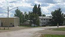
Clavet, Saskatchewan
| Village of Clavet | |
|---|---|
|
Queen Street | |
| Motto: "A great place to live!" | |
 Location of Clavet in Saskatchewan | |
| Coordinates: 51°58′44″N 106°19′52″W / 51.979°N 106.331°W | |
| Country | Canada |
| Province | Saskatchewan |
| Region | Saskatchewan |
| Census division | 11 |
| Rural Municipality | Blucher |
| Post office Founded | 1904 (as "French") |
| Incorporated (Village) | 1908 (as "French") |
| Government | |
| • Mayor | Blair Bentley |
| • Village Manager | Janet Patry |
| • Governing body | Clavet Village Council |
| Area | |
| • Total | 0.61 km2 (0.24 sq mi) |
| Population (2006) | |
| • Total | 345 |
| • Density | 561.2/km2 (1,454/sq mi) |
| Time zone | CST |
| Postal code | S0K 0Y0 |
| Area code(s) | 306 |
| Highways | Highway 16 |
| Website | http://villageofclavet.com |


Clavet (pronounced "cluh vet") is a village located in central Saskatchewan, Canada. It is located on the Yellowhead Highway, about 15 kilometres southeast of Saskatoon.
History
Originally established as French, Saskatchewan the name of the community was changed to Clavet on December 1, 1909.[1] Due to its low population level, in 1927 the village was dissolved, with administrative responsibilities transferred to the rural municipality of Blucher; it was not until 1964 that the population reached a point that permitted Clavet to become an organized municipality again.[2]
Services
In Clavet there is a motel (and bar), one gas station, an auto repair shop, and a school. The school is kindergarten to grade twelve and it is named after the town (Clavet School). Clavet is approx. 30 minutes away from downtown Saskatoon.
Transportation
Clavet is located along the Saskatchewan Highway 16, just south of where it joins with Saskatchewan Highway 316.
The Saskatoon/Corman Air Park is located west of Clavet.
The Canadian National Railway passes through the village of Clavet.
Demographics
| |||||||||||||||||||
See also
References
- ↑ "Database of Postpasters". Library and Archives Canada. Retrieved 2011-03-06.
- ↑ "Village of Clavet - History". Village of Clavet. Retrieved 2011-03-06.
- ↑ "2006 Community Profiles". Canada 2006 Census. Statistics Canada. March 30, 2011. Retrieved 2011-03-06.
- ↑ "2001 Community Profiles". Canada 2001 Census. Statistics Canada. February 17, 2012. Retrieved 2011-03-06.
External links
 |
Saskatoon | Aberdeen | St. Denis |  |
| Casa Rio | |
Colonsay | ||
| ||||
| | ||||
| Dundurn | Shields | Bradwell |
Coordinates: 51°58′44″N 106°19′52″W / 51.979°N 106.331°W