Civic Center / UN Plaza Station
|
Rapid transit (BART) Light rail (Muni) | |||||||||||||||||||||||||||||||||||||||||||||||||||||||||||||||||||||||||
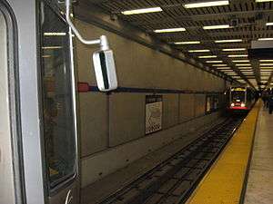
 A Muni Metro train (foregound) waiting in the station level while another train (background) is boarding passengers | |||||||||||||||||||||||||||||||||||||||||||||||||||||||||||||||||||||||||
| Location |
1150 Market Street San Francisco, CA 94102 | ||||||||||||||||||||||||||||||||||||||||||||||||||||||||||||||||||||||||
| Coordinates | 37°46′47″N 122°24′49″W / 37.779861°N 122.413498°WCoordinates: 37°46′47″N 122°24′49″W / 37.779861°N 122.413498°W | ||||||||||||||||||||||||||||||||||||||||||||||||||||||||||||||||||||||||
| Platforms | 2 island platforms (1 per level) | ||||||||||||||||||||||||||||||||||||||||||||||||||||||||||||||||||||||||
| Tracks | 4 (2 per level) | ||||||||||||||||||||||||||||||||||||||||||||||||||||||||||||||||||||||||
| Connections |
AC Transit Golden Gate Transit Valley of the Moon Commute Club Kaiser Shuttle Yellow Line | ||||||||||||||||||||||||||||||||||||||||||||||||||||||||||||||||||||||||
| Construction | |||||||||||||||||||||||||||||||||||||||||||||||||||||||||||||||||||||||||
| Disabled access | Yes | ||||||||||||||||||||||||||||||||||||||||||||||||||||||||||||||||||||||||
| History | |||||||||||||||||||||||||||||||||||||||||||||||||||||||||||||||||||||||||
| Opened |
November 5, 1973 (BART) February 1980 (Muni) | ||||||||||||||||||||||||||||||||||||||||||||||||||||||||||||||||||||||||
| Traffic | |||||||||||||||||||||||||||||||||||||||||||||||||||||||||||||||||||||||||
| Passengers (FY 2013) |
20,342 exits/day[1] | ||||||||||||||||||||||||||||||||||||||||||||||||||||||||||||||||||||||||
| Services | |||||||||||||||||||||||||||||||||||||||||||||||||||||||||||||||||||||||||
| |||||||||||||||||||||||||||||||||||||||||||||||||||||||||||||||||||||||||
Civic Center/UN Plaza is a BART and Muni Metro station in the Civic Center of San Francisco. The westernmost of the dual BART/Muni stops on the Market Street Subway, Civic Center/UN Plaza acts as a major hub for passenger movement throughout the San Francisco Bay Area. With 18,432 exits each weekday, it is the fourth-busiest station in the BART system.
Location
Outside, in the United Nations Plaza itself, facing Market Street, there is a fountain and a north-south cross marking its center to be at latitude/longitude coordinates 37°46′48″N 122° 24′49″W. There is a flea market at the plaza or farmer's market every day, year round.
There are several notable buildings in the Civic Center area, including City Hall, the War Memorial Opera House, Asian Art Museum, Louise M. Davies Symphony Hall. The San Francisco Public Library's main branch is located across the street and San Francisco City Clinic is 2 blocks east on 7th street.
History
Service at this station began on November 5, 1973.[2]
Station layout
| G | Street Level | Exit/Entrance | |
| M | Mezzanine | One-way faregates, ticket machines, station agent | |
| B1 | Outbound | ← ← ← ← ← ← | |
| Inbound | → → → → → → | ||
| B2 | Southbound/Westbound | ← Pittsburg/Bay Point–SFO/Millbrae toward SFO weekdays, Millbrae weekends (16th Street Mission) ← Dublin/Pleasanton–Daly City toward Daly City (16th Street Mission) ← Richmond–Daly City/Millbrae toward Millbrae weekdays, Daly City Saturdays (16th Street Mission) ← Fremont–Daly City toward Daly City (16th Street Mission) | |
| Northbound/Eastbound | → Pittsburg/Bay Point–SFO/Millbrae toward Pittsburg / Bay Point (Powell Street) → → Dublin/Pleasanton–Daly City toward Dublin / Pleasanton (Powell Street) → → Richmond–Daly City/Millbrae toward Richmond (Powell Street) → → Fremont–Daly City toward Fremont (Powell Street) → | ||
Like all stations in the Market Street Subway apart from Van Ness, Civic Center/UN Plaza has a tri-level configuration. Passengers first descend from the street to a mezzanine concourse containing faregates for passengers to enter separate BART and Muni paid areas, with one BART entrance on each end and one for Muni in the middle. Muni Metro trains stop at an island platform on the second level down. The Muni platform is punctured in several locations by openings for stairs and escalators that go directly from the mezzanine level to the BART platform, bypassing the Muni platform. As the openings are not blocked off by walls, it is possible to hear activity on the Muni platform from the BART platform.
See also
References
- ↑ "BART Fiscal Year Weekday Average Exits". Bay Area Rapid Transit (BART). Retrieved 13 Nov 2013.
- ↑ BART History, BART.gov. 2010. Access date 07-12-2010.
External links
 Media related to Civic Center / UN Plaza Station at Wikimedia Commons
- BART – Civic Center Station Overview
- Street map from Mapquest
| ||||||||||||||||||||||||||||||||||||||||||
